In the article on "Early History of the Hong Kong Observatory" published in the July 2021 issue of the HKLF Newsletter, we introduced the history of the Observatory from the time around the establishment of the Observatory to World War II. We now introduce the history and development of the Observatory since World War II.
Test of The War
Hong Kong came under the attack of the Japanese army on the morning of 8 December 1941 and was occupied by the Japanese on 25 December 1941. The Observatory was forced to suspend its service [1]. During the Japanese occupation of Hong Kong from 1941 to 1945, the Observatory Headquarters was mainly used for operating two anti-aircraft guns. According to recovered records [2], weather observations were conducted by Japanese weather corps soldiers stationed at the Observatory Headquarters (Fig 1). Although the Observatory buildings suffered only superficial damages, almost all the equipment was removed.
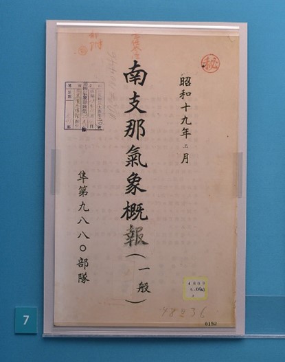
Fig 1: South China Weather Report for May 1944 includes the meteorological records made by the Japanese soldiers at the Hong Kong Observatory during World War II. (Courtesy of Prof Togo TSUKAHARA, Kobe University)
During the Japanese occupation period, the then Director, Mr B D EVANS, was interned at the Stanley Internment Camp. The then Assistant Director, Mr G S P HEYWOOD and his colleague, Mr L STARBUCK, were imprisoned at the Sham Shui Po Prisoner-of-War Camp. Despite the harsh environment, Mr Evans continued to maintain intermittent weather observations manually or by using simple equipment. These wartime meteorological data were recorded on ledger sheet, letter paper, wrapper of cigarettes pack, and back of animal cards that came with canned biscuits.
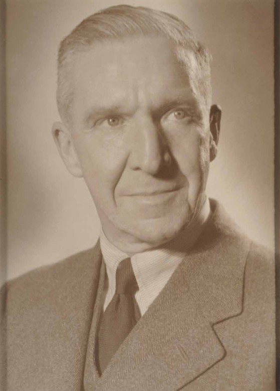
Fig 2: Mr B D EVANS, the Director of the Hong Kong Observatory who persisted in making weather observations while interned at the Stanley Internment Camp during the Japanese Occupation.
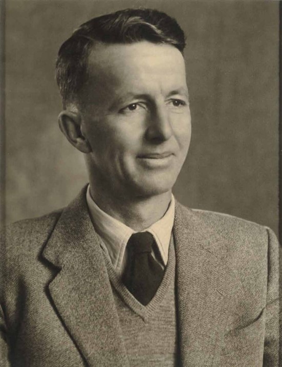
Fig 3: Mr G S P HEYWOOD, survived the nearly four years of daunting life in the Sham Shui Po Prisoner-of-War camp during the Japanese occupation. He wrote a diary entitled "It won't be long now" [3] and took records of tidal observation (Fig 8).
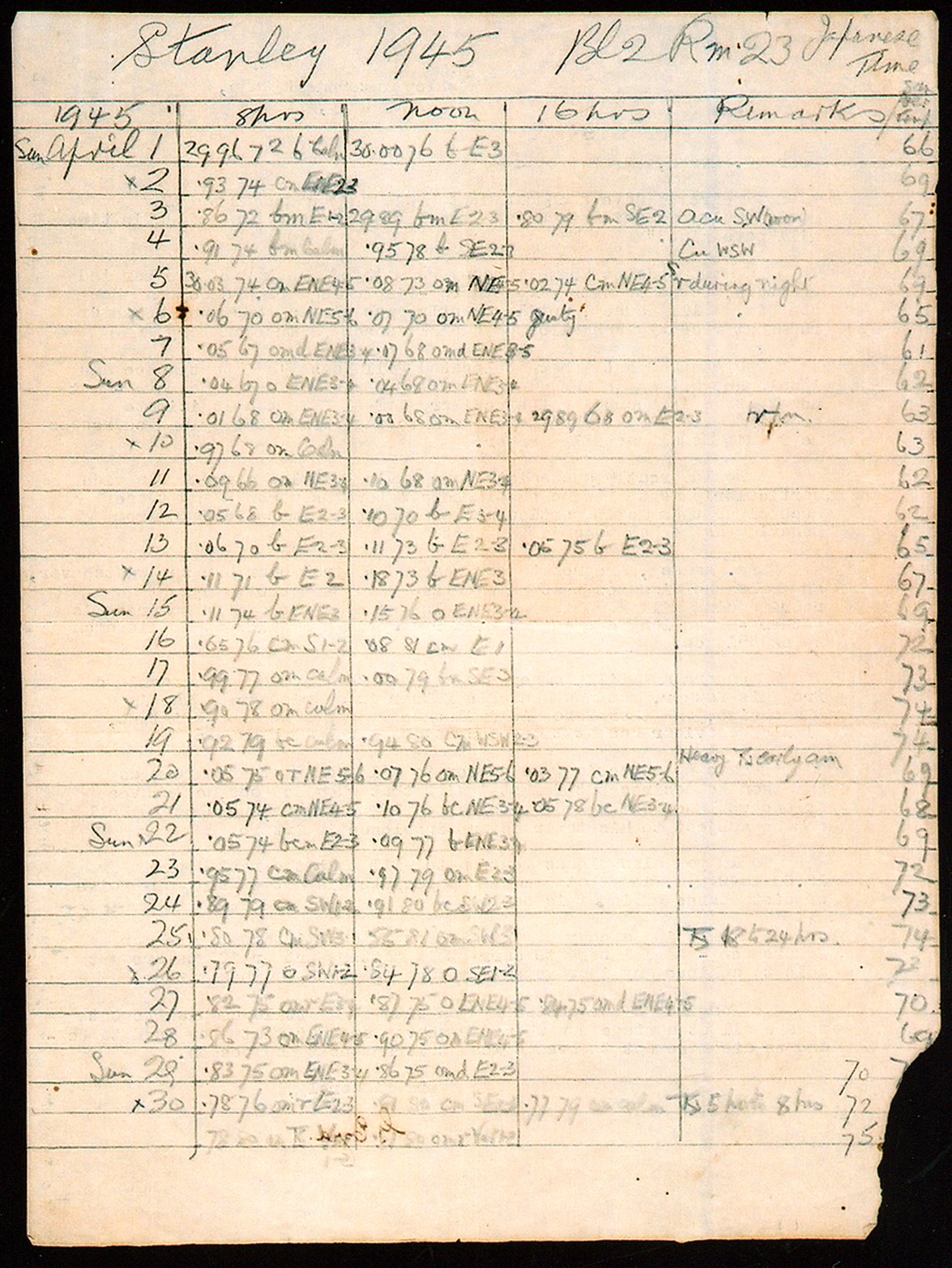
Fig 4: Weather report of 1945 at Stanley during the Japanese occupation of Hong Kong. (Photo courtesy of the Public Records Office, Hong Kong)
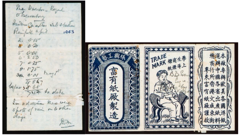
Fig 5: Rainfall record of April 1943 on the wrapper of cigarettes pack with the signature of Mr Evans in the Internment Camp. (Photo courtesy of the Public Records Office, Hong Kong)
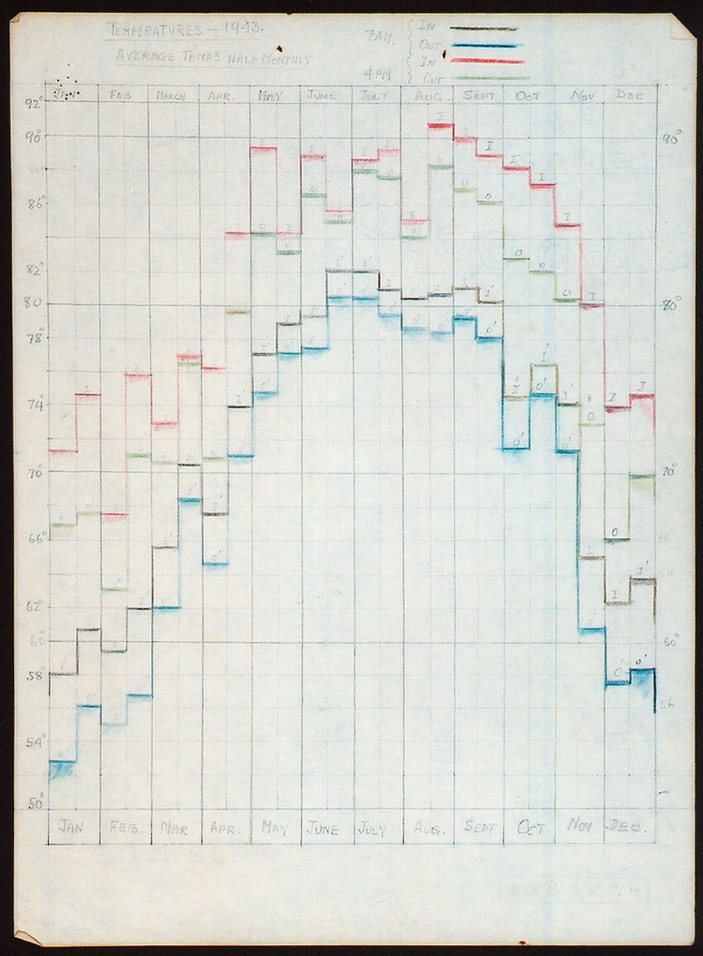
Fig 6: Temperature records of 1943 written on Internment Camp letter paper during the Japanese occupation of Hong Kong. (Photo courtesy of the Public Records Office, Hong Kong)
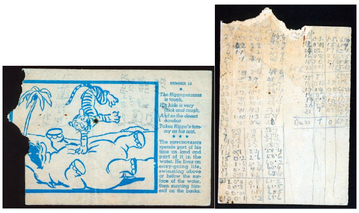
Fig 7: Meteorological data recorded by the Observatory's staff during the Japanese occupation on the back of animal cards that came with canned biscuits. (Photo courtesy of the Public Records Office, Hong Kong)
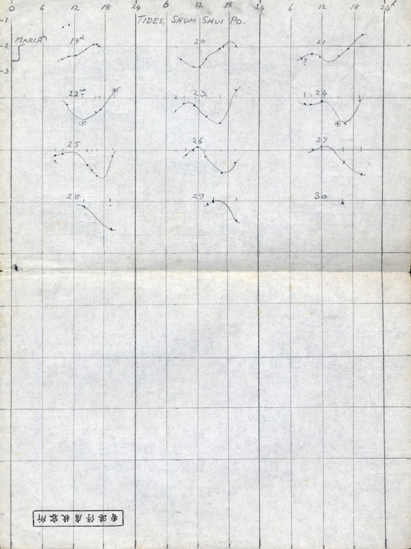
Fig 8: Records of tidal observations conducted by Mr G S P HEYWOOD at the Sham Shui Po Prisoner-of-War camp during the Japanese occupation. (The tidal records were provided by the family of Mr G S P HEYWOOD and are kept in the History Room of the Observatory)
Post-war Service Development
After the end of World War II, the Observatory Headquarters was taken over by the Royal Navy and Royal Air Force. In 1945, Chinese staff of the Observatory jointly requested for reinstating their work. When the Hong Kong Government regained control of the Observatory on 1 May 1946, staff of the Observatory were reinstated. Mr G S P HEYWOOD, who was imprisoned in the Sham Shui Po Prisoner-of-War camp, became the first post-war Director of the Observatory. Meteorological observations at the Observatory resumed progressively since 9 May 1946 [4]. Aviation weather services also resumed in a Nissen hut at the Kai Tak Airport in August 1947. In May 1948, the Airport Meteorological Office moved into the operations building, enhancing its operation efficiency [5].
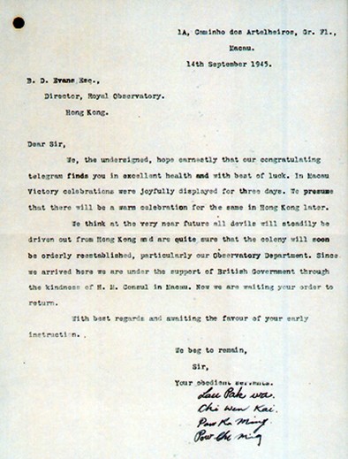
Fig 9: Letter by Observatory staff in 1945 requesting for reinstatement after the end of Japanese occupation of Hong Kong. (Photo courtesy of the Public Records Office, Hong Kong)
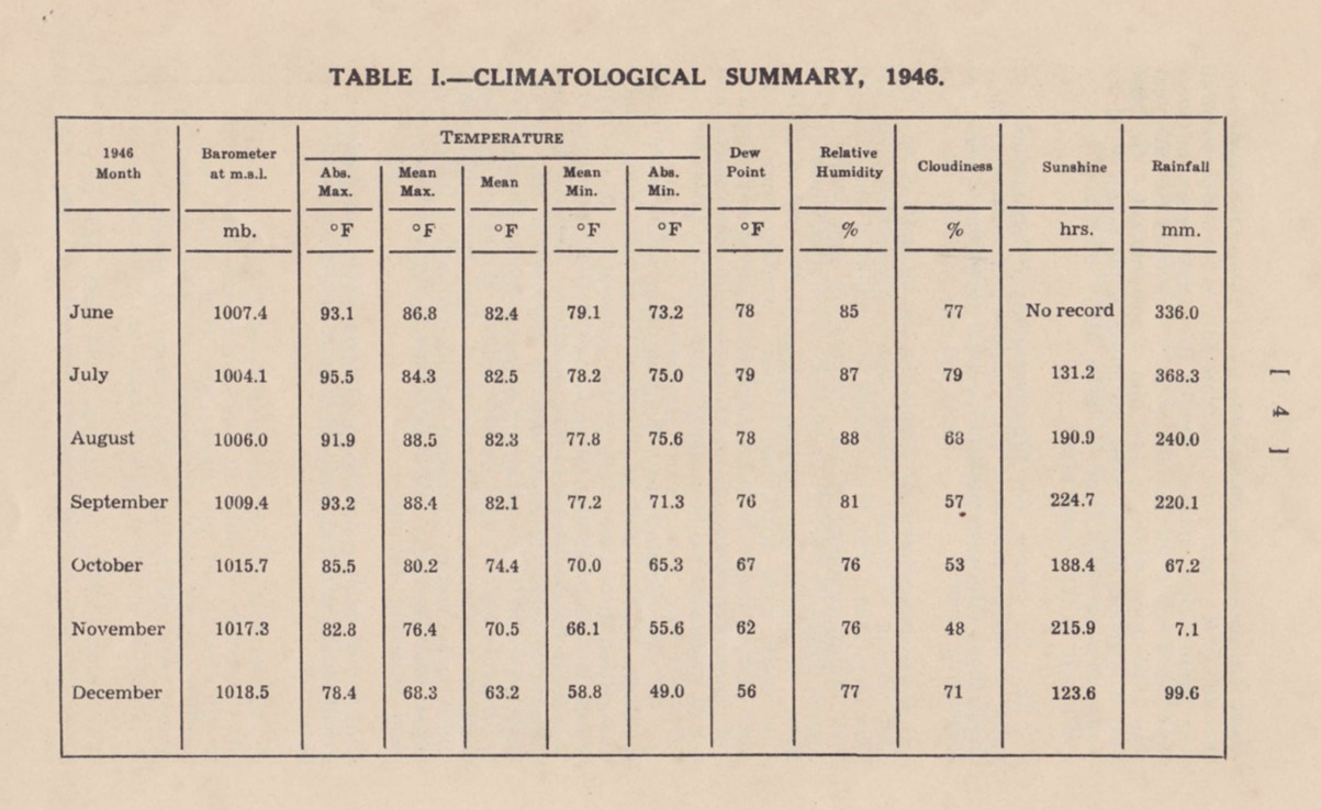
Fig 10: The Climatological Summary of Hong Kong from June to December 1946 documented in the Director’s Report published in June 1947.
(1) Surface meteorological observations
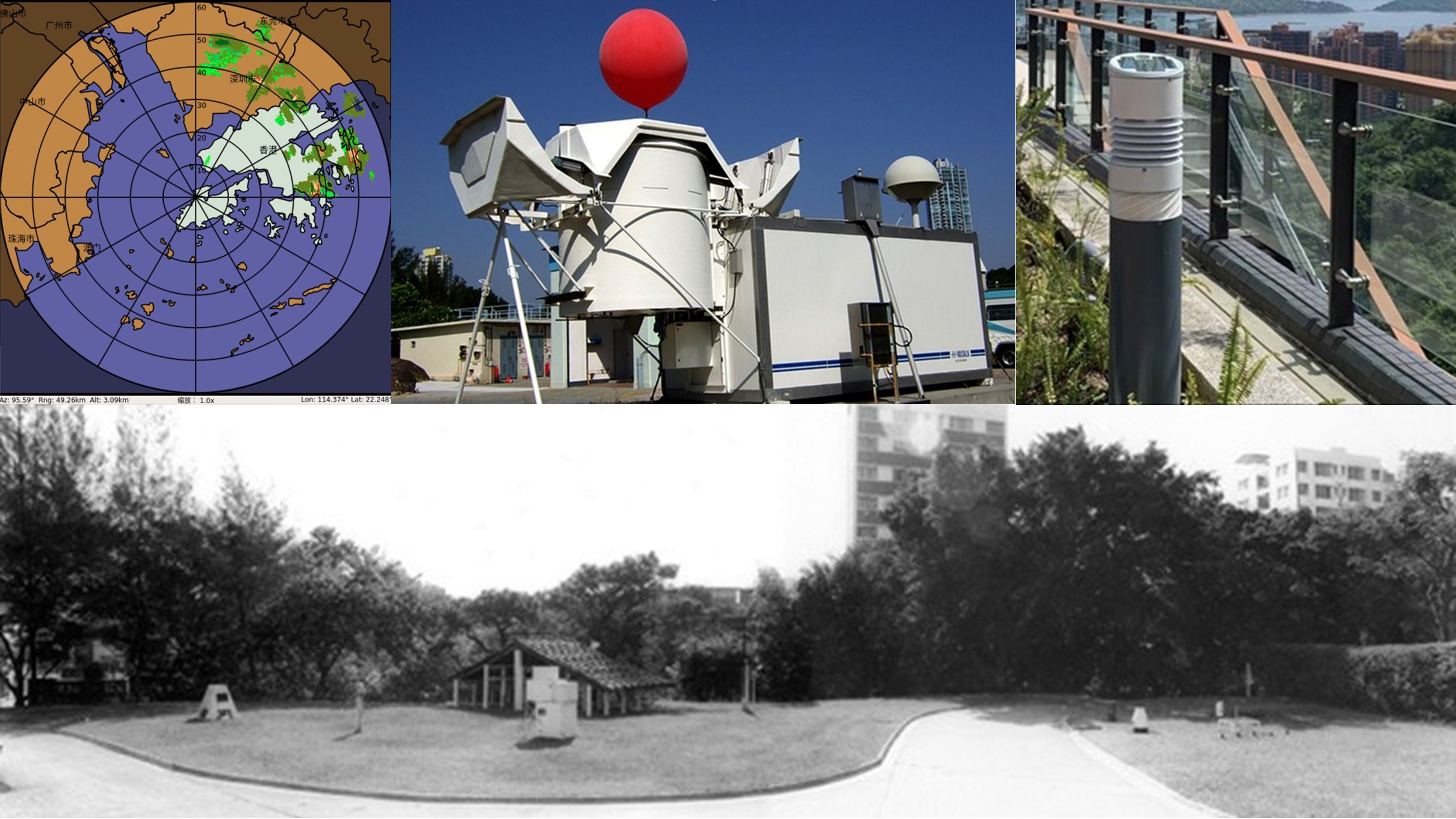
Since World War II, the types of weather elements observed by the Observatory continued to increase. In 1947, the Observatory began visibility observations. The measurement of soil temperature and grass minimum temperature also commenced in 1949-1950. From 1952 to 1953, weather stations were established at Waglan Island and Cheung Chau to support aviation weather service. Measurement of solar radiation commenced at the Observatory Headquarters in 1958. The instrument was relocated to the King’s Park Meteorological Station in 1959. The Observatory also commenced daily measurement of evapotranspiration and evaporation at King’s Park in 1951 and 1957 respectively. In the mid-1950s, the Observatory utilised a modified windfinding radar, and a marine radar on loan from the Police, to detect successfully distant rain. The Observatory's first storm-detecting weather radar was installed at Tate's Cairn in 1959. After replacement of the radar twice, the Observatory implemented Hong Kong’s first Doppler weather radar in 1994. This radar made use of "Doppler effect" to detect the speed of movement of raindrops to aid estimation of storm’s structure and intensity. In 1999, the Observatory installed another Doppler weather radar at Tai Mo Shan, the highest peak in Hong Kong, to strengthen the reliability of storm detection. In end-2021, the Observatory installed its first phased array weather radar for trial use of this new technology to enhance the capability in monitoring storms and intense convection. Phased array weather radar adopts electronic scanning method to enable it to scan the atmosphere quickly.
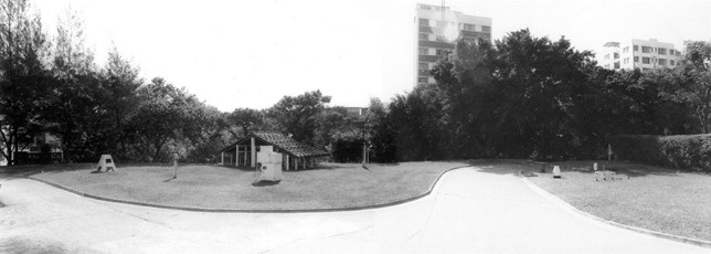
Fig 11: Panoramic view of the lawn area of the Observatory (towards south). This photo was likely taken in early 1970s.
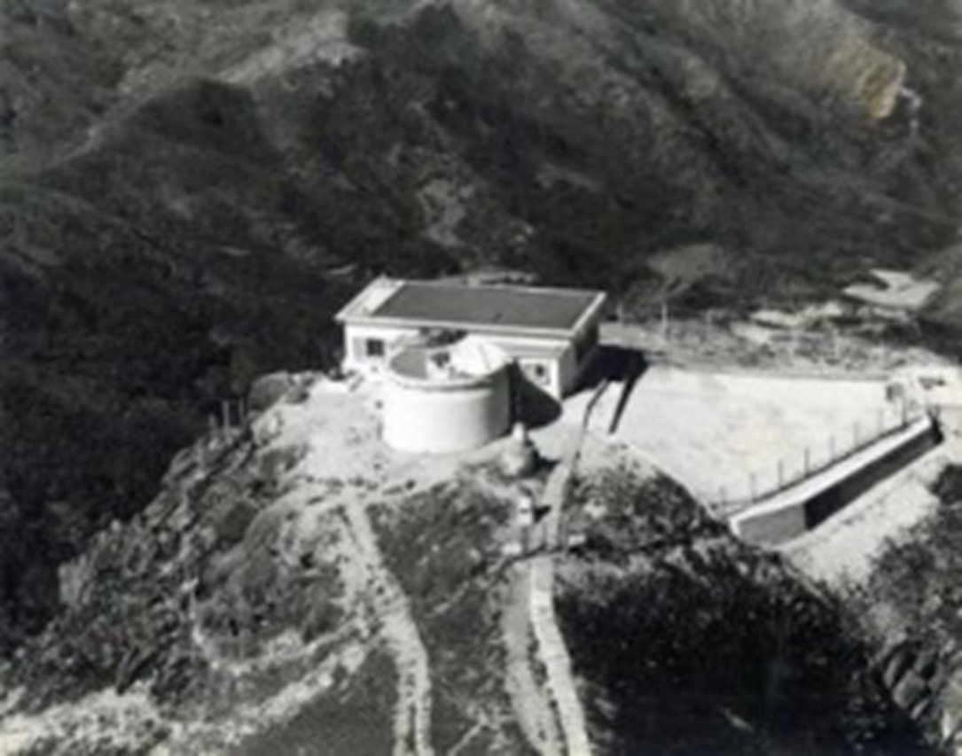
Fig 12: The Observatory's first weather radar at Tate's Cairn.
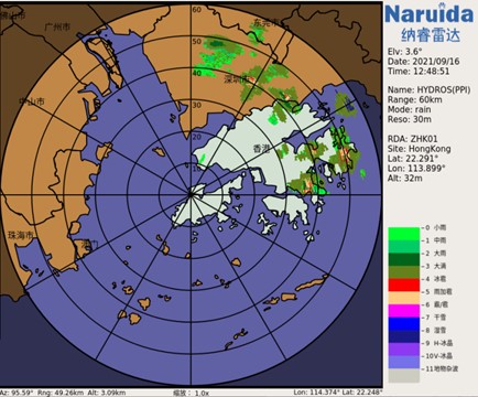
Fig 13: The Observatory’s first phased array weather radar detected hails (in red colour) over the eastern part of Hong Kong after noon time on 16 September 2021.
In end-1970s, the Observatory employed integrated circuit and microprocessor technologies to develop automatic rain gauge and automatic weather station. This helped extending weather observations to different places in Hong Kong and even to neighbouring areas (Fig 14), and improving the frequency and types of observations. For instance, in 2005 the Hong Kong Observatory collaborated with Guangdong Province and Macao to implement a lightning location system, providing real-time lightning information. The Observatory also installed webcams in different districts of Hong Kong to provide real-time weather photos starting the same year. In 2009, the Observatory even successfully registered a patent in Hong Kong for its in-house developed "Heat Stress Monitoring System". The system calculates the Hong Kong Heat Index, which is tailored for the situation in Hong Kong and is used to enhance the heat stress information service. In 2020, the Observatory developed in-house a design of bollard type automatic weather station, which was also successfully registered for a patent in Hong Kong. The new design enables various meteorological sensors be accommodated in a tiny enclosure. This resolves the issues of installing automatic weather station in a city of limited space and facilitates the future development in microclimate monitoring.
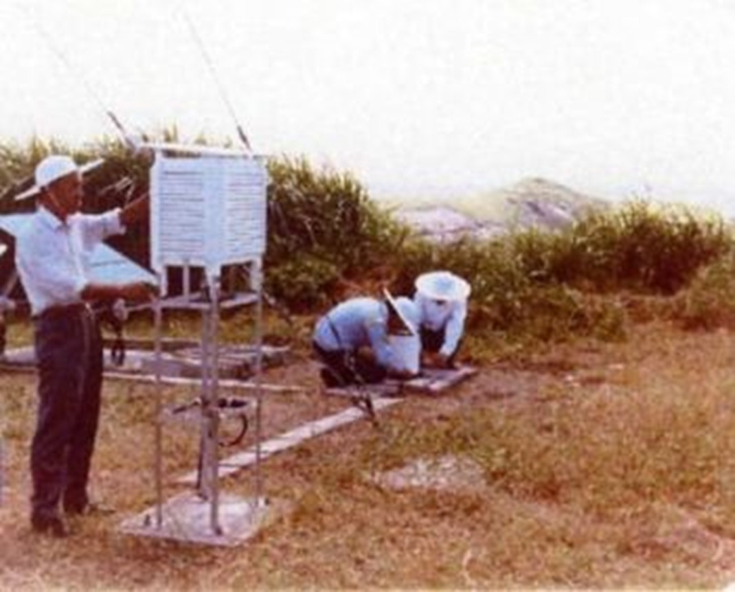
Fig 14: Hong Kong Observatory collaborated with Guangdong Meteorological Bureau to jointly establish the first automatic weather station on Huangmaozhou of Zhuhai in July 1985.
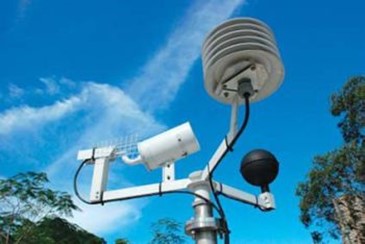
Fig 15: "Heat Stress Monitoring System" developed in-house by the Observatory.
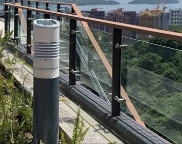
Fig 16: "Bollard type automatic weather station" developed in-house by the Observatory.
As part of the feasibility study for a replacement airport, the Observatory started to operate a manned temporary meteorological station at Chek Lap Kok in 1979. An experimental windshear warning system for Kai Tak Airport was commissioned in September in the same year. The meteorological station at Chek Lap Kok was blown down by Typhoon Ellen in September 1983 and was subsequently replaced by an automatic weather station which operated until levelling of the site for construction of the new airport in 1991. In October 1995, a new automatic weather station was set up at the levelled Chek Lap Kok airport construction site. Manual observation by weather observer at Chek Lap Kok started in April 1996.
The Hong Kong International Airport at Chek Lap Kok was opened in July 1998. A series of meteorological systems for the new airport was also put into operation. These include the aerodrome meteorological observing system and the weather radar [6] for windshear [7] detection. To enhance windshear monitoring under rain free situation, the Observatory introduced in 2002 the world’s first Doppler LIDAR [8] for airport weather monitoring. LIDAR can detect the movement of particulates in the air for monitoring of windshear on flight paths. In 2005, the in-house developed and the world’s first LIDAR windshear alerting system was put into operation. This system filled the technological gap in windshear detection in clear air, and was highly recognised by the international aviation and meteorological community. The LIDAR windshear alerting system won the Award of the Year, the top award in the Hong Kong ICT [9] Awards 2009. At the same time, it also won the Best Innovation and Research Grand Award as well as the Gold Award for the Open Stream. The Observatory also installed several weather buoys in the vicinity of the airport for monitoring weather around the airport, especially for early warning of windshear brought by sea breeze. The Observatory used short-range LIDAR at the airport for detecting turbulence induced by buildings commencing 2009 and for detecting wake vortex commencing 2014. The Observatory also installed one more weather radar at Brothers Point for windshear detection to enhance flight operation safety.
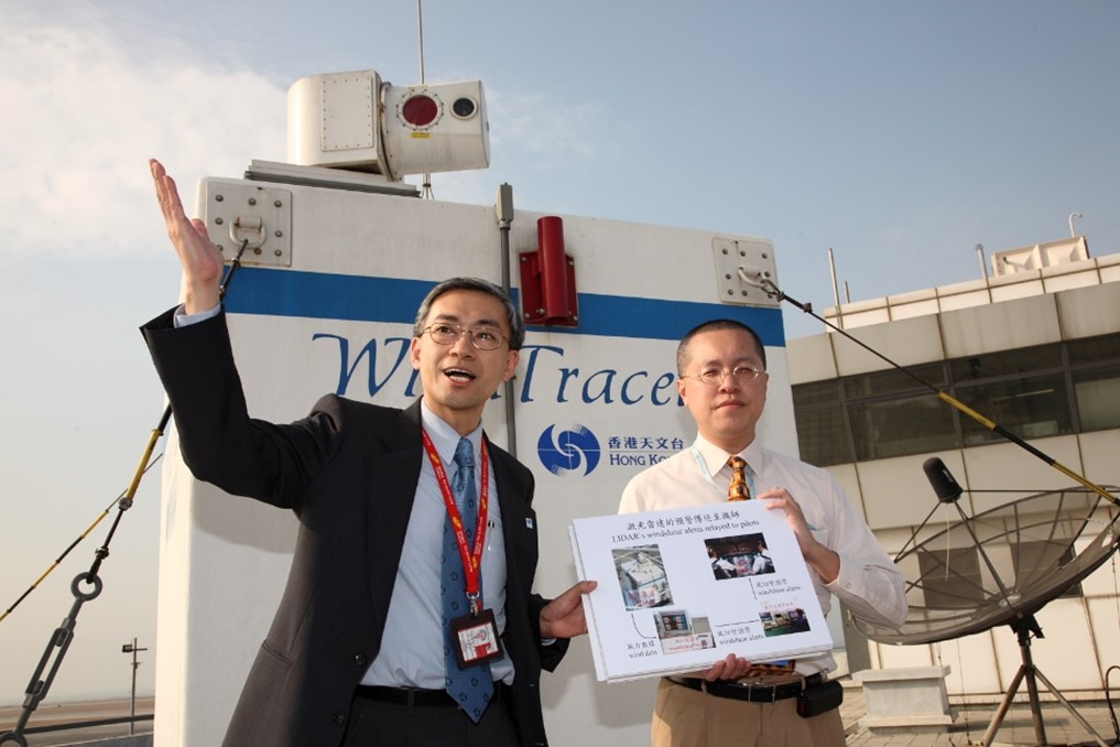
Fig 17: Mr SHUN Chi-ming, Senior Scientific Officer at the time, led a small team to develop the LIDAR-based windshear alerting system. The system commenced its dual-LIDAR operation in 2007.
In the early years, the Observatory made use of instruments to observe tide in Tsimshatsui, Kowloon. The observations for 1887-1888 were used to make tide tables, but the tide observation based on instrument ended in 1890. Thus, Hong Kong’s early tide data came mainly from manual observation using tide pole. In the 1950s, the Observatory set up automatic tide gauge at the Arsenal base. This tide gauge was relocated to North Point in 1952 and further to Quarry Bay in 1985. The concurrent observations at North Point and Quarry Bay compared well with each other. As such, the tide records from the two tide stations can be considered coming from one single station. The combined tide records from North Point and Quarry Bay is the longest tide record in Hong Kong. Other automatic tide stations were installed in different locations in the 1960s. In 2020, the Observatory operates a network of tide gauge stations at Tsim Bei Tsui, Tai Po Kau, Quarry Bay, Tai Miu Wan, Shek Pik and Waglan Island. The Observatory started to produce its own tidal predictions for 1987 and thereafter based on a computer programme acquired from overseas and publish tide tables for Hong Kong.
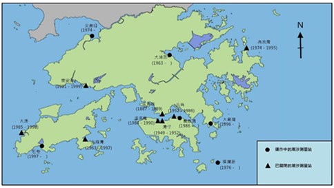
Fig 18: Locations of tide stations operated by the Observatory since 1883 and locations of the two closed tide stations at Wan Chai and North Point
(2) Upper-air meteorological observations
Operations of upper-air meteorological observation continued to develop after the war. In 1949, the first upper-air sounding system using radiosonde was installed at the Hong Kong Observatory Headquarters and routine upper-air observations were carried out at 8 am daily. The staff of the Observatory manually inflated and released a balloon that was tied with a radiosonde and a radar reflector. When the balloon ascended, the radiosonde sent the upper-air pressure, temperature and humidity data measured by the sensors back to the ground station at the Observatory Headquarters using radio signals. Meanwhile, the Observatory used a theodolite installed on the rooftop of the Observatory Headquarters to record the direction and elevation of the balloon for calculating the upper-air wind direction and speed. Routine upper-air meteorological observations were made at the Observatory Headquarters every morning until the end of May 1951. Starting from 1 June 1951, routine upper-air observation was then made at the King’s Park Meteorological Station every morning. This marked the end of the 30-year glorious mission of upper-air meteorological observations at the Observatory Headquarters from 1921 to 1951.
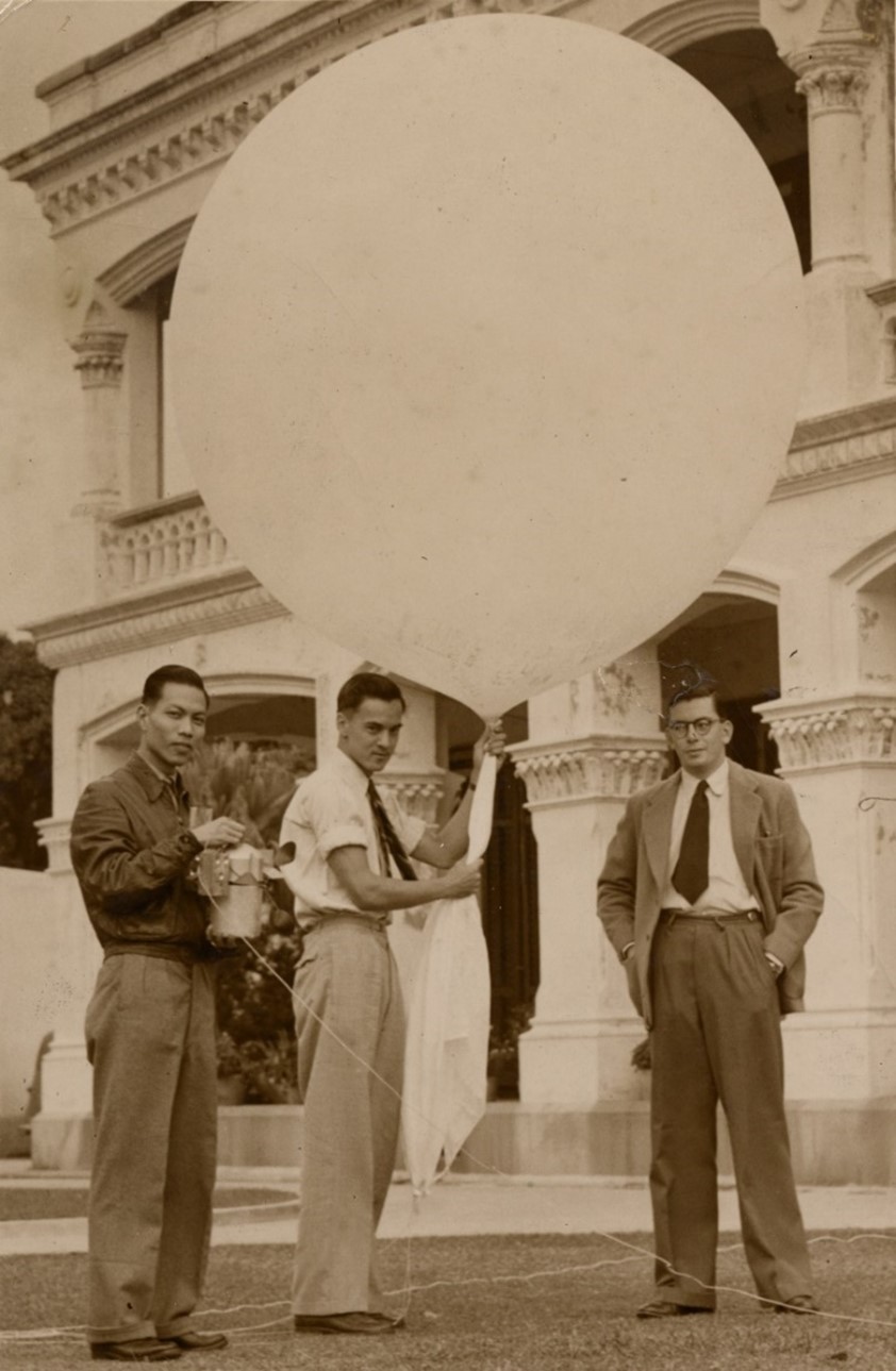
Fig 19: The Hong Kong Observatory staff introduced the upper-air sounding system to the media on 16 December 1949. (Courtesy of Mr SHUN Chi-ming, former Director of the Hong Kong Observatory)
In conducting upper air sounding at King’s Park Meteorological Station, a radar reflector would be attached to the upper air sounding balloon in addition to a radiosonde. The Observatory staff employed a ground-based army radar to track the movement of the radar reflector and determined its range, direction and elevation, from which the upper level wind direction and speed could be computed. A newly installed windfinding radar was used instead of the army radar on 1 January 1955.
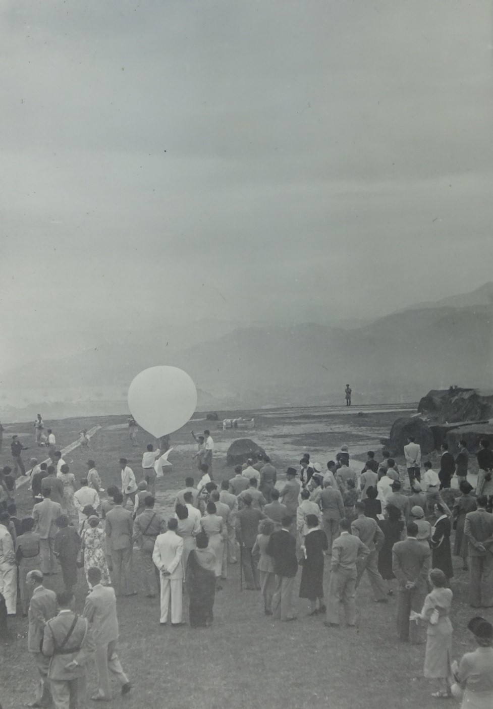
Fig 20: The inauguration ceremony of the King's Park Meteorological Station on 9 November 1951. (Courtesy of the family of Mr L STARBUCK, former Deputy Director of the Hong Kong Observatory)
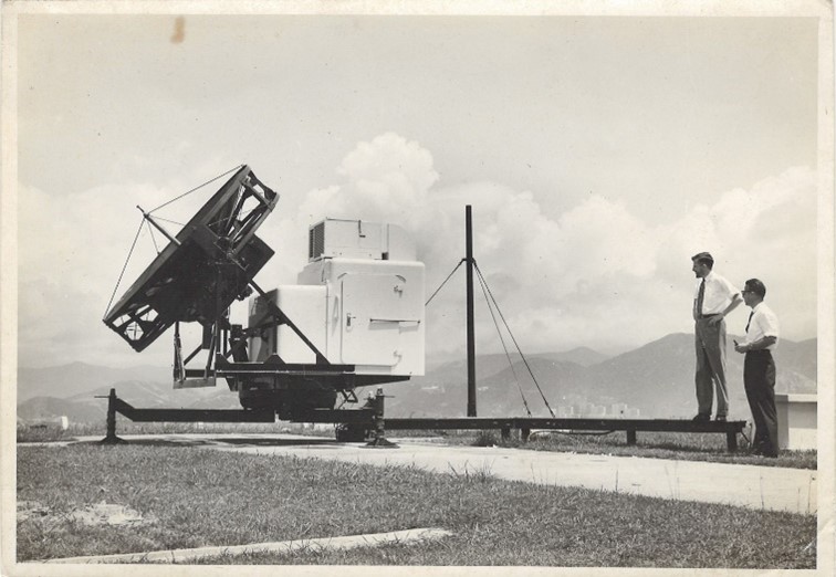
Fig 21: The windfinding radar at King’s Park Meteorological Station in 1962. (Courtesy of Mr Peterson, former Senior Scientific Officer)
In 1993, the Observatory adopted a digital sounding system that, in addition to performing routine upper-air weather measurement, supported also specially designed detectors to measure upper-air ozone content as well as gamma and beta radiation levels. Since then, the Observatory has been monitoring upper-air ozone content at the King’s Park Meteorological Station once a week, and regularly conducting upper-air radiation measurement under different weather conditions each year. In 2004, the Observatory installed a fully automatic upper-air sounding system, the first of its kind in Southeast Asia, at the King’s Park Meteorological Station. This not only reduced operating costs and increased work efficiency, but also enhanced the safety of personnel in work. In November 2019, the King's Park Meteorological Station was awarded a certificate by the World Meteorological Organization (WMO) in recognition of its long-term contribution to supporting the Global Climate Observing System (GCOS) Upper Air Network (GUAN). In 2020, the King’s Park Meteorological Station became a candidate site of the GCOS Reference Upper Air Network (GRUAN) of the WMO, and commencing October that year, cryogenic frost-point hygrometer was launched monthly as required to provide long-term and high-quality upper-air atmospheric water vapour content data to the meteorological community. In 2021, the upper air observing station in Hong Kong became the world's first centennial upper-air observing station accredited by the WMO.
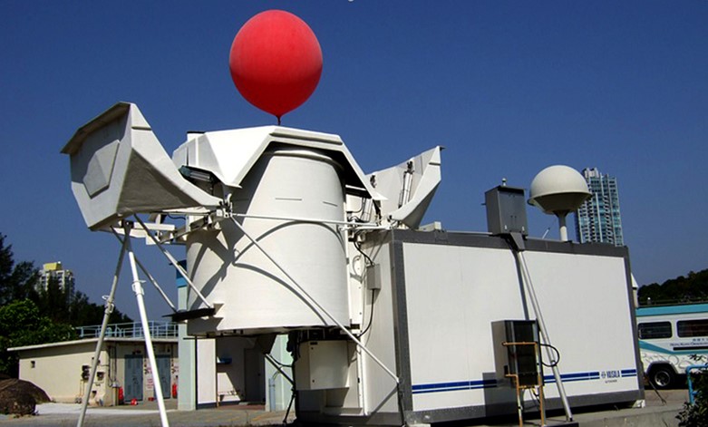
Fig 22: The fully automatic upper-air sounding system was commissioned at King's Park Meteorological Station in 2004, the first of its kind in Southeast Asia at that time.
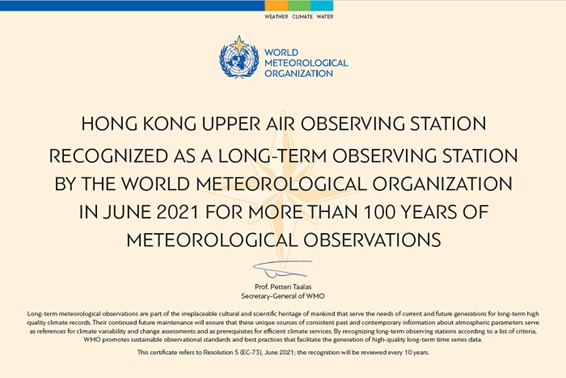
Fig 23: The long-term observing station accreditation certificate awarded by the WMO to the Hong Kong Upper Air Observing Station.
In the mid-1960s, the Observatory started using in-house developed radio antenna and equipment at King’s Park to receive satellite images from the meteorological satellites launched by the USA. In the following decades, the Observatory installed more ground reception systems to receive satellite images and data from the satellites of the Mainland, Japan and the Republic of Korea, and to receive global satellite images via the Internet.
Fig 24: The Observatory staff used in-house designed equipment to receive images from the satellites of the USA at the King's Park Meteorological Station in the mid-1960s.
In 2003, automatic weather reports were successfully received for the first time from computers on board a commercial aircraft. The next year, the Observatory started operational reception and disseminate to the world automatic weather reports from commercial aircraft. The number of participating aircraft increased gradually from one at the start of this system to 49 in 2020.
In 2011, the Observatory, in collaboration with the Government Flying Service, deployed a fixed-wing aircraft to fly into tropical cyclones over the South China Sea to collect meteorological data for the first time in 2011, and releasing dropsondes from high altitude to collect the meteorological data at various heights in the vicinity of a tropical cyclone since 2016. The data is valuable to the Observatory in determining the location and intensity of a storm.
Fig 25: The old and new fixed wing aircraft operated by the Government Flying Service.
(3) Tropical cyclone warning service
1. Development of the tropical cyclone warning system
After the Second World War, with non-local warnings being disseminated to ships through radio, the provision of non-local signals by visual means ceased at the end of June 1961.
To meet the needs of development of the society, the local storm signal system has evolved in phases after the World War II. In 1956, the No 3 Strong Wind Signal was introduced between the No 1 Stand-by Signal and the No 5 Gale Wind Signal.
Fig 26: Aerial photo of the Observatory Headquarters in 1950s showing the signal mast (on the right side of the photo) for hoisting the tropical cyclone warning and strong monsoon signals.
Starting from 1973, the Observatory re-numbered the gale wind signals No 5 to No 8 of the warning system as No 8 Northwest, No 8 Southwest, No 8 Northeast and No 8 Southeast respectively so as to avoid misunderstanding of the public on the meaning of wind direction and wind strength. This led to the current 1-3-8-9-10 scheme of tropical cyclone warning system, which remains in use today.
Moreover, a "Local Strong Wind Signal" in the form of black ball, was once introduced by the Observatory on 1 January 1950 to warn small crafts of the onset of strong winds due to monsoon or weaker tropical cyclones. With effect from 15 April 1956, the Observatory introduced the Strong Monsoon Signal (Black Ball) and the Tropical Cyclone Strong Wind Signal No 3 (inverted T symbol) to replace the "Local Strong Wind Signal" to distinguish between the warning signals for monsoon and tropical cyclones.
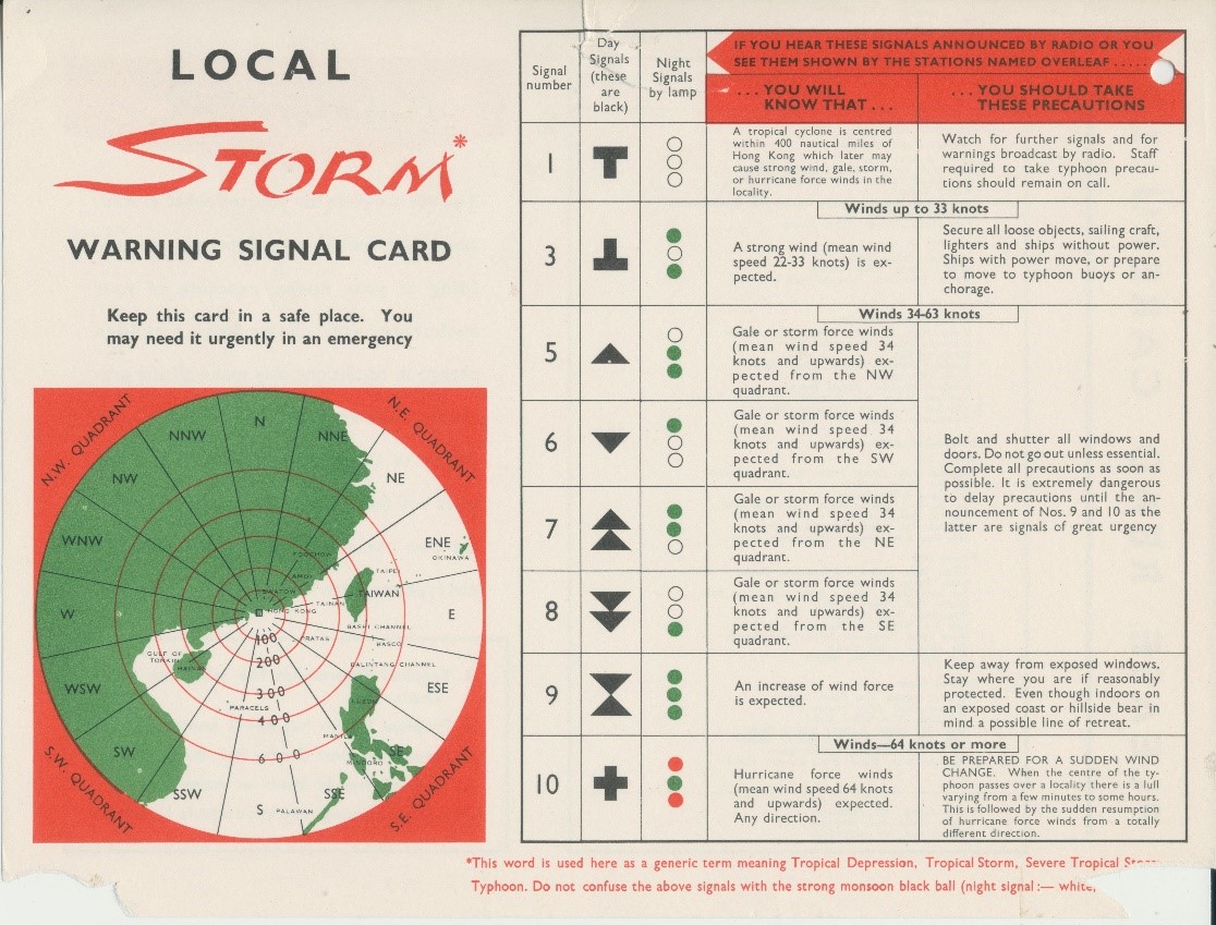
Fig 27: Local Storm Signal in the late 1950s and 1960s.
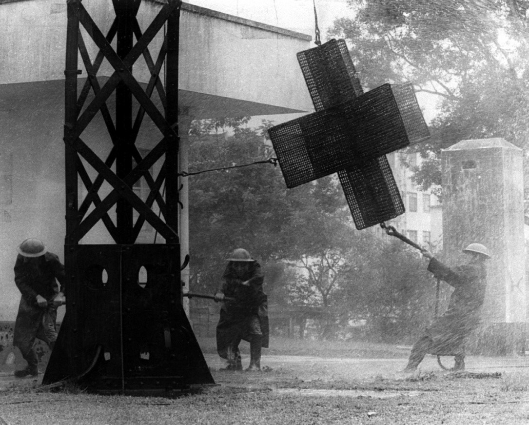
Fig 28: Hoisting Hurricane Signal No 10 at the Headquarters of the Hong Kong Observatory.
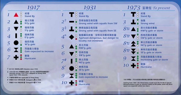
Fig 29: Major evolution of the numbered tropical cyclone warning signal system in Hong Kong since 1917.
With the advancement of communication technologies, the signal stations that conveyed only visual information became obsolete and inadequate, and the Observatory closed down these stations progressively since the late 1970s. Hong Kong’s last signal station at Cheung Chau was decommissioned on 1 January 2002, marking the end of the era of hoisting tropical cyclone warning signals. More information about the evolution of the tropical cyclone warning systems in Hong Kong over the years can be found in the relevant Technical Note of the Observatory [10].
Apart from the changes in the Tropical Cyclone Warning System, the Observatory progressively improves the accuracy, forecast period and geographical coverage of tropical cyclone forecast through scientific research and innovation. The validity period of forecast track and intensity of tropical cyclone was extended from 2 days in 1978 to 3 days in 2003, and further to 5 days in 2015. In 2017, the Observatory launched the "Tropical Cyclone Track Probability Forecast" as a new service providing the probability of tropical cyclone forecast track in the coming 9 days. The geographical coverage was extended in 2020 out to the longitude of 180 degrees East over the western North Pacific.
2. Storm surge and high waves induced by tropical cyclones
In addition to heavy rain and squalls, tropical cyclones also bring storm surges and high waves that can cause serious inundation in the coastal areas. For the first time in history, in September 1962, storm surge was predicted for Tolo Harbour in the warning for Tropical Cyclone Wanda which brought the highest tide level records in both the Victoria Harbour and Tolo Harbour after World War II. The storm surges brought by tropical cyclones Hope in 1979 and Ellen in 1983 also worth mentioning. In 2008, Tropical Cyclone Hagupit skirted 180 kilometers south-southwest of Hong Kong, causing flooding in many low-lying areas in Hong Kong. The inundation in Tai O in the western part of Lantau Island was particularly serious. In 2009, the Observatory began providing location-specific early alerts of serious inundation for Tai O under the respective contingency plan. This storm surge alerting service was gradually expanded to a number of other areas in Hong Kong that were prone to storm surges and high waves, enabling relevant government departments to initiate contingency plans as soon as possible to reduce the impacts of inundation to local residents.
After Tropical Cyclone Hato wreaking havoc and bringing significant storm surge in 2017, the storm surge and high waves brought by Tropical Cyclone Mangkhut in 2018 caused even more serious damages to many coastal facilities in Hong Kong, including sewage treatment works, public beaches, and waterfront promenades. The sea levels recorded at Quarry Bay and Tai Po Kau were the highest since Tropical Cyclone Wanda in 1962.
(4) Development and modernisation of weather service
1. Weather forecast services
With the advancement in forecasting technology, the Observatory progressively extended the forecast range to 3 days in 1983, 4 days in 1998, 5 days in 2000, 7 days in 2003, and further to 9 days in 2014. Besides the 9-day weather forecast, the Observatory started to provide hourly forecasts for the next 9 days at different locations in Hong Kong through the "Automatic Regional Weather Forecast" webpage in 2013. In 2017, the Observatory launched the "Extended Outlook" forecast service to provide the probability forecasts of daily minimum and maximum temperatures for the next 14 days. The probability forecast of mean sea level pressure was subsequently launched in 2019 to facilitate the public in getting hold of the upcoming weather changes.
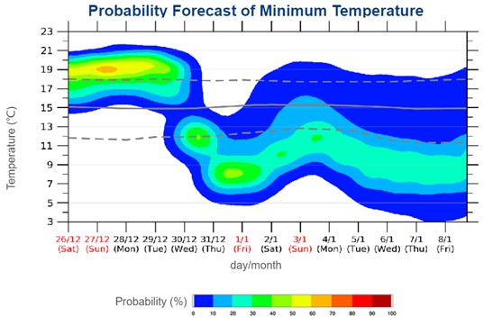
Fig 30: Probability Forecast of Daily Minimum Temperature for the next 14 days.
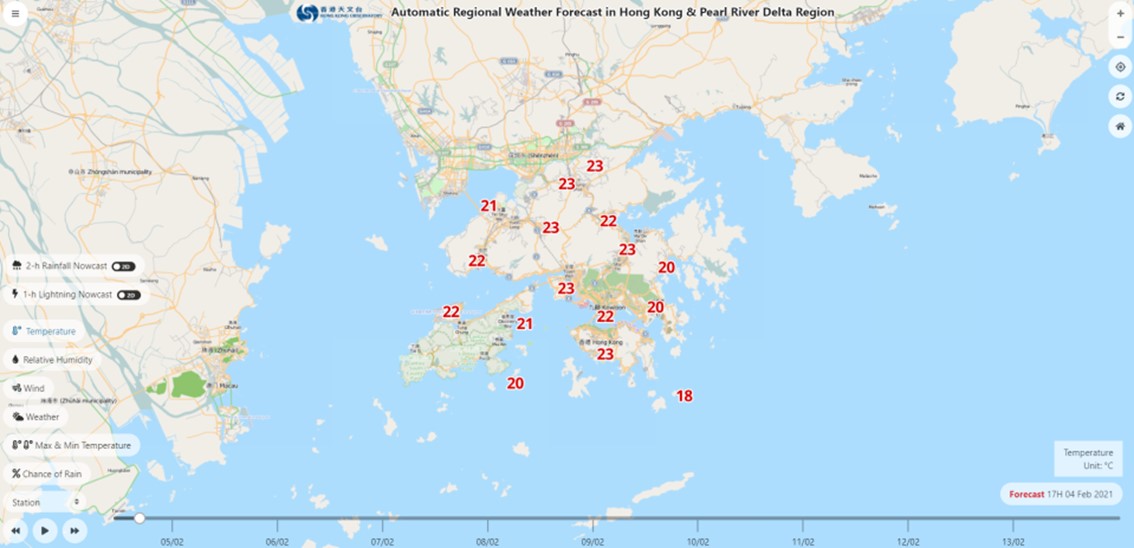
Fig 31: Webpage on "Automatic Regional Weather Forecast"
To handle forecasting of severe weather, to enhance the warning services, to protect the safety of the public and to safeguard the operation of various organisations in the society, the Observatory commenced the development of a nowcasting system known as SWIRLS (Short-range Warning of Intense Rainstorms in Localised Systems) in 1997. The system was put into operation in 1999. SWIRLS utilises observations including radar, rainfall and lightning data, as well as computer model outputs to generate forecasts of rainstorms and associated severe weather for the next few hours. Apart from supporting the operation of rainstorm and landslip warnings in Hong Kong, the Observatory also collaborated closely with meteorological services in the Mainland, including those in Shanghai, Guangdong and Shenzhen, to furthering the scientific research and applications of SWIRLS. SWIRLS demonstrated its strengths at the Beijing 2008 Olympic Forecast Demonstration Project under the World Weather Research Program of the WMO, and was further employed to support 2010 World Expo in Shanghai, the 2010 Commonwealth Games in Delhi and the 2011 Summer Universiade in Shenzhen.
In view of lightning threat to the airport, the Observatory launched an Airport Thunderstorm and Lightning Alerting System in 2008 providing lightning alerts to personnel on the apron of the airport.
In 2012, the Observatory launched 2-hour rainfall nowcast service on its website and "MyObservatory" mobile app. In 2017, 1-hour lightning nowcast service was launched to enable members of the public to readily obtain forecast of high impact weather.
The Observatory has been collaborating with the universities in Hong Kong in recent years to conduct research on applying deep learning on nowcasting. The Observatory also collaborated with the State Meteorological Agency of Spain to develop nowcasting techniques based on satellite data in order to enhance nowcasting performance. The SWIRLS developed in-house by the Observatory won the Smart Business Grand Award and the Smart Business (Solution for Business and Public Sector Enterprise) Gold Award of the Hong Kong ICT Awards 2019.
2. Weather warning services
Apart from tropical cyclone warnings, the Observatory also developed other types of severe weather warning systems. The rainstorm in June 1966 resulted in serious causalities in Hong Kong. The Observatory started issuing thunderstorm and heavy rain warning from 1967 onwards. During the rainstorm on the morning of 8 May 1992, the Observatory recorded nearly 110 millimetres of rainfall in an hour that set the highest hourly rainfall record at that time. Serious flooding and landslides occurred in many places on that day, paralysing the traffic in various districts. This event also brought fatalities. This rainstorm led to the establishment of the Rainstorm Warning System, in which the warning was issued based on recorded rainfall. In 1998, the Rainstorm Warning System was revised with the use of amber, red and black colours to indicate the severity of rainstorms, and incorporated forecast rainfall in order to give early alert on imminent rainstorms to facilitate early preparation.
Owing to the hilly landscape of Hong Kong, heavy rain in summer often came with landslides. In the 1970s, Hong Kong experienced a number of serious landslides, resulting in numerous fatalities and property losses. With the establishment of the Geotechnical Engineering Office, the Observatory introduced in 1977 the Landslip Warning for emergency response units. The Landslip Warning was simplified and its dissemination to the public commenced in 1983. In the same year, the Observatory introduced the Flood Warning System to warn against the risk of flooding associated with heavy rain. This Flood Warning System was abolished upon the introduction of the Rainstorm Warning System in 1992. Commencing 1998, a Special Announcement on Flooding in the northern New Territories will be issued by the Observatory whenever flooding is expected to occur or is occurring in the low-lying plains of northern New Territories.
Apart from rain-related warnings, the Observatory commenced to operate the "Grass Fire Warning" that was only issued during public holidays since 15 November 1968. The Observatory started to issue the Yellow and Red Fire Danger Warning signals from 1972. In 1999, the Observatory introduced the Cold Weather Warning to remind the public to take care of the elderlies or persons with chronic medical conditions. The Very Hot Weather Warning was introduced in the same year to raise public awareness in preventing heatstroke.
To meet the increasing demand of the public on weather services, the Observatory has been providing "Special Weather Tips" to members of the public in recent years before the criteria for issuing weather warnings are reached. For example, under relatively high temperature, humid and light wind conditions, the Observatory would consider issuing the "Hot Weather Special Advisory" to alert the public of the risk of heatstroke even if the weather conditions remain below the criteria for issuing the Very Hot Weather Warning. Similar service was also introduced for heavy rain in 2016. When heavy rain is limited to a particular district in Hong Kong, posing serious threat of flooding there but not yet extending generally over Hong Kong and reaching the criteria for a Red or Black Rainstorm Warning signal, the Observatory will issue the Announcement on Localised Heavy Rain to alert the public of potential flooding in affected districts due to heavy rain, so that the public can take precautionary measures. This Announcement on Localised Heavy Rain service was replaced in 2021 by the Localised Heavy Rain Advisory service that takes into account the nowcast rainfall in addition to recorded rainfall, aiming to advise people of localised heavy rain as early as possible.
The weather warnings issued by the Observatory will trigger the contingency plans of various government departments, public utilities and non-governmental organisations and facilitate early preparation and reduction in loss of life.
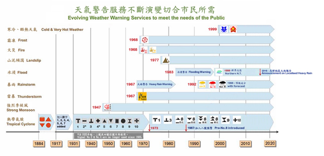
Fig 32: Evolving Weather Warning Services to meet the needs of the Public.
3. Seasonal and long-term forecasts
In addition to the 9-day weather forecast, the Observatory also provides long-range forecasts to the general public. In the 1970s, the Observatory provided long-range rainfall forecast to Water Supplies Department to support water resource management. With increasing public and media demand for long-range forecast, the Observatory began to disseminate annual outlook to the general public in the early 2000s. This forecast covers the annual Hong Kong rainfall in categorical terms and the annual number of tropical cyclones affecting Hong Kong. In the mid-2000s, the Observatory began to disseminate seasonal forecast on its website, predicting seasonal average temperature and total rainfall in categorical terms.
4. Release of information and public communication
The Observatory’s services went in tandem with the development of technology over the past 130 odd years, from the use of physical tropical cyclone signals, newspapers, and radio in early days, to the later use of television and telephones, and more recently the use of Internet, mobile app and social media, etc. to effectively disseminate weather information to the public.
In the early years after the end of World War II, weather reports and forecasts issued by the Observatory were broadcast twice a day in Chinese and English via Radio Hong Kong. In the late 1950s, the number of daily broadcasts increased gradually. Since 1955, 12-hour weather forecasts for local fishermen in fishing areas along the South China coast were produced by the Observatory, and were broadcast to the fishermen in Cantonese via Radio Hong Kong. The forecasts were extended to 24 hours in 1960. In 1960-61, weather information issued by the Observatory was distributed to the local media through the Information Services Department of the Hong Kong government [11].
As time went by, public demand for weather information was also increasing. The Observatory applied the latest technology to provide weather information services to the public. In 1985, the Observatory used advanced communication equipment to set up an automatic telephone enquiry system called "Dial-a-Weather", which, not requiring a lot of manpower to support, enabled the public to obtain the latest weather information via telephone. Since 1987, the Observatory launched television (TV) weather programme service. The TV weather programmes hosted by the Observatory staff brought weather information to every household through TV. Commencing 2013, the Observatory launched its self-produced free TV weather service for many local TV stations, featuring regular TV weather programmes and educational video series called "Cool Met Stuff" to enhance public science education.
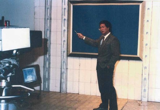
Fig 33: Since 1987, Scientific Officers of the Hong Kong Observatory have been making weather presentations on television, bringing weather services to every household.
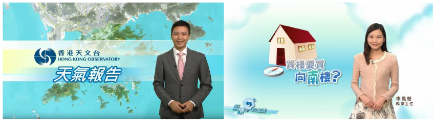
Fig 34: In 2013, the Observatory launched in-house produced free public television weather service, including routine television weather programmes (left) and educational video series named "Cool Met Stuff" (right).
At the end of the 20th century, the emergence of Internet brought unprecedented opportunities for development of weather services. The Observatory established its website as early as 1996. In 2000, the annual total number of page views of the Observatory's website was close to 50 million. From 2000 to 2009, the Observatory continued to strengthen the content of its website. A mobile version designed specifically for mobile devices was launched in 2001. During these 10 years, the annual total page views of the Observatory’s website increased by 32 times, reaching 1.59 billion in 2009.
With the advent of Internet 2.0, the Observatory started to set up a channel (hkweather) on the video-sharing website YouTube in 2009 to provide weather-related knowledge to the public through video every week. Later in 2013, more contents, including TV weather programmes and "Cool Met Stuff", were included.
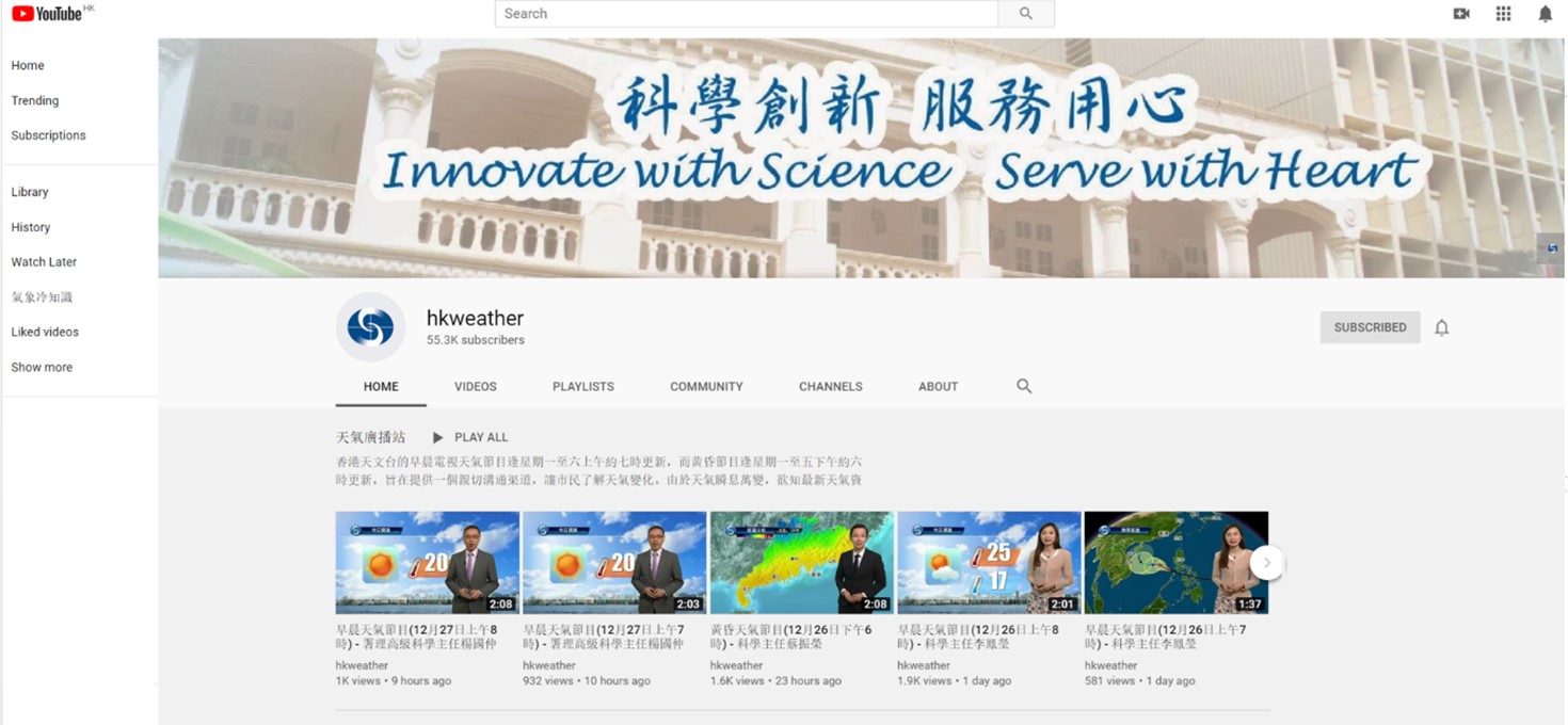
Fig 35: The Hong Kong Observatory set up an account on YouTube in 2009 for uploading television weather videos of the Hong Kong Observatory.
In addition to video-sharing website, the Observatory started providing weather information to the public on other social media websites such as Twitter, Weibo, and WeChat commencing 2010. In March 2018, the Observatory also launched its Facebook Page "香港天文台HKO" and the "hk.observatory" Instagram platform. In addition to disseminating messages more effectively, creative means of explaining meteorological knowledge is adopted to enhance public engagement.
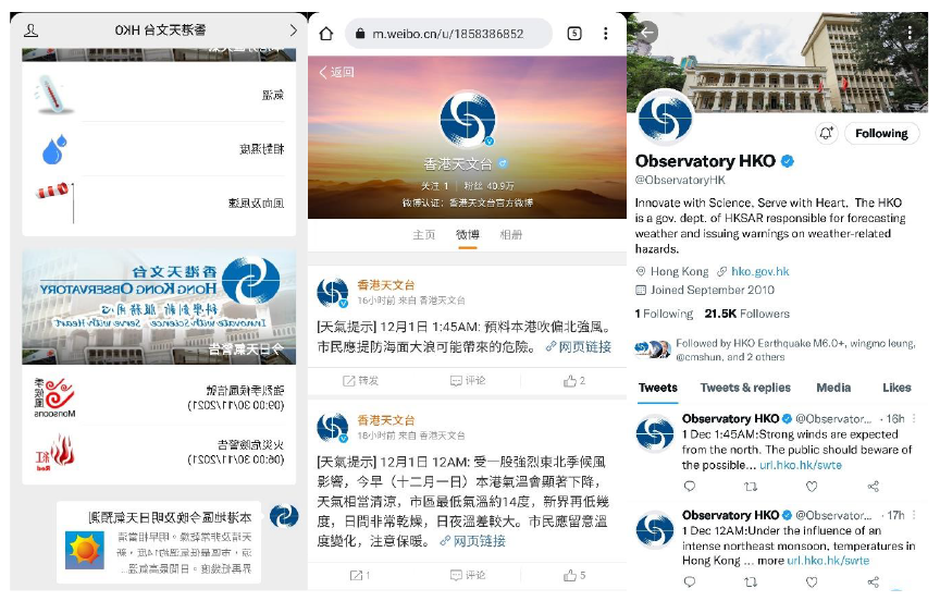
Fig 36: The Observatory started providing weather information to the general public via social media channels WeChat (left), Weibo (centre), and Twitter (right) in 2010.
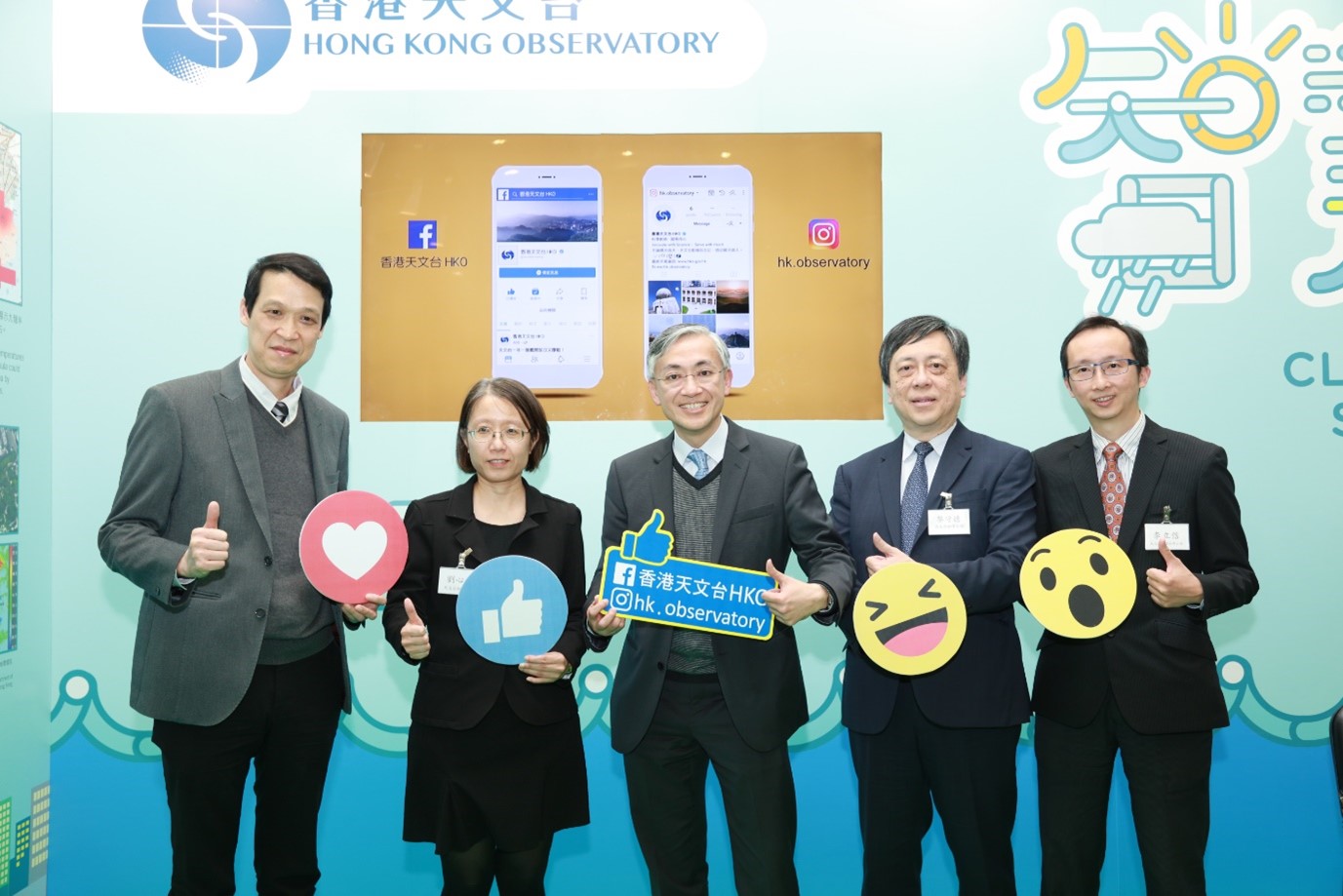
Fig 37: The Observatory launched "香港天文台 HKO" Facebook page and "hk.obervatory" Instagram platform in March 2018.
In mid-2009, in view of the increasing popularity of smartphones with the introduction of the third-generation mobile network (3G), the Observatory developed a mobile weather app "MyObservatory", which was launched in early 2010. In addition to providing users with the convenience of surfing online weather information anytime and anywhere, the mobile weather app offers an opportunity in providing personalised weather services. It becomes a brand-new platform for the Observatory to develop weather information service in the following decade. In 2013, the usage of the "MyObservatory" mobile app surpassed that of the Observatory's website for the first time. By the end of 2020, the total number of downloads of "MyObservatory" exceeded 8.3 million, which was more than the total population of Hong Kong. In 2020, the total page views of the Observatory's online information service (including mobile app and websites) was close to 158 billion, which was 99 times more than that in 2009. In 2020, the "MyObservatory" won an award in "Public weather forecasts and information - information content" category of the WMO International Weather Apps Awards 2020, and won an honourable mention in the "Specialised apps award - weather warnings" category.
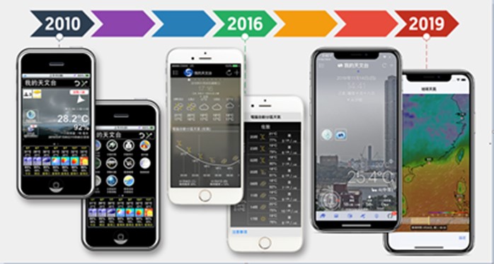
Fig 38: The total number of downloads of the "MyObservatory" mobile app exceeded 8.3 million by 2020, whilst the total page views of the Observatory's online information service exceeded 158 billion in the same year.
In the big data era, the Observatory launched a trial feature of "My Weather Observation" on "MyObservatory" to allow the public to report such weather and optical phenomena as hail and rainbow, etc. Members of the Community Weather Observation Scheme can also upload weather photos and video clips through "MyObservatory". The scheme aims to raise public’s awareness and understanding on different weather situations through crowdsourcing of weather information.
To provide quality climate information service, the Observatory enhanced its website by launching a new Climatological Information Services webpage in 2006. This new webpage aids the public, students, researchers, engineering professionals and the media in searching for climate information.
In addition to developing the "MyObservatory" mobile app to serve the general public, an Android mobile app "MyAeroMET" was developed in 2013 to aid users in the aviation community in accessing aeronautical meteorological information. Subsequently the Observatory also collaborated with Cathay Pacific Airways to jointly develop the "MyFlightWx" mobile app, which is fully compatible with the crew’s workflow and provides real-time information dedicated for individual flight. The "MyFlightWx" mobile app was put to operational use at cockpits of all Cathay Pacific aircraft in 2019. "MyFlightWx" is the world's first electronic flight bag weather mobile app developed in-house by a meteorological authority.

Fig 39: Mr SHUN Chi-ming (left), the then Director of the Hong Kong Observatory, and the Chief Operations and Service Delivery Officer of Cathay Pacific Airways, Mr Greg HUGHES, showcasing the mobile application "MyFlightWx" in a flight simulator.
Stepping into the 2020s, artificial intelligence (AI) developed rapidly in various fields, and its applications became popular. The Observatory also applied AI technology to develop new services. A pilot chatbot service that employed AI in identifying user’s questions was launched in 2020 on the "MyObservatory" mobile app, website, etc. The service became very popular after launch, handling about 4,000 messages per day on average. The number of messages soared to over 30,000 per day during the days with high weather impact. The launch of the chatbot service also reduced the workload of frontline staff.
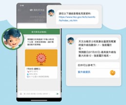
Fig 40: Chatbot "Dr Tin" developed by employing AI technology
(5) Numerical weather prediction and high-performance computing yystems
Numerical weather prediction (NWP) refers to the use of high-performance computing systems to simulate the physical change in atmosphere to predict the future weather. It is one of the main methods in modern weather forecasting. The Observatory introduced regional NWP models as early as 1989 to produce its own short-term weather forecasts over southern China. With the increasing processing power of computer systems, horizontal model resolution of the Observatory’s forecast model saw a corresponding increase from the initial 100 km (1989, Limited Area Model) gradually to 20 km (1999, Operational Regional Spectral Model) and recently 2 km (2010, Non-Hydrostatic Model) or below. Trials on regional ensemble prediction and global NWP are also underway with a view to enhancing support for impact assessment and regional collaboration.
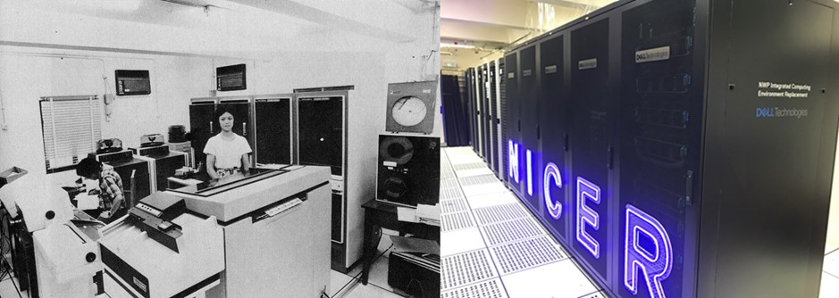
Fig 41: (Left) The Observatory installed its first computer system, with a computing speed of 10 FLOPS, in 1973. (Right) By 2019, the speed of the Observatory’s high-performance computing system has reached 200 TFLOPS.
(6) Time services
The three pendulum clocks of the Observatory that were used before the war all luckily survived the war. After the Observatory resumed its operations in 1946, one of these pendulum clocks was adopted as the time standard. It was regulated by radio time signals from other time centres in the world. In 1950, an electro-mechanical synchronous standard pendulum clock that could provide time signals was installed. Timing accuracy improved to within one-fifth of a second per day. The flashing light time service and the radio time service resumed in 1950-51. On 11 April 1953, Radio Hong Kong began broadcasting hourly six-pip time signals of Hong Kong Standard Time provided by the Observatory.
In 1966, a quartz-controlled timing system was implemented to replace the pendulum clocks. By comparing daily the time signals received from other centres in the world, the time accuracy was kept within 80 milliseconds per day. In the same year, the Observatory commenced direct broadcasting of the 6-pip time signal on 95 MHz at 15-minute intervals, which lasted until 16 September 1989.
On 1 January 1972, Hong Kong adopted the Coordinated Universal Time (UTC) as the official time standard, with a time zone of UTC+8 hours. In 1980, a timing system based on a Caesium Beam Atomic Clock was acquired, with an accuracy of within a microsecond a day, and was traceable to the primary standard at the Communications Research Laboratory in Japan.
In 2004, the Observatory installed a high accuracy time transfer system that employed the Global Positioning System common-view method to provide time information of the Observatory’s atomic clock to the Bureau International des Poids et Mesures (BIPM) for determination of UTC. The Hong Kong Observatory also adjusts its atomic clock based on time information provided by BIPM.
In 2012, the Observatory launched the IPv6 network time service to provide accurate, more direct and low-latency time signals in supporting the setting up of network facilities and servers over IPv6 networks in Hong Kong. The service can be accessed through the Observatory's Network Time Protocol (NTP) servers at the network address of time.hko.hk for calibrating the computer clocks. Besides, the Observatory also provides web clock service, enabling direct access by members of the public to the standard time from the Observatory's atomic clocks via computers or mobile phones.
In 2019, the accuracy of the Observatory's time system based on Caesium Beam Atomic Clocks has further improved to within 0.01 microsecond a day. Such a level of accuracy is particularly useful to scientists, industries and other professionals. The Observatory's network time service served more than 43 billion synchronisations in 2020.

Fig 42: Synchronous standard pendulum clock providing time service in Hong Kong from 1950 to 1966.
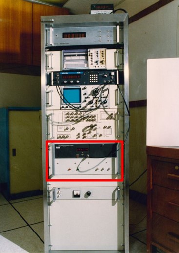
Fig 43: The first Caesium Beam Atomic Clock (marked in red) installed in 1980 for maintaining the Hong Kong time standard and operating local time service.
(7) Geomagnetic observation
On 8 December 1941, the operation of the geomagnetic station at Au Tau in the northwestern part of Hong Kong was terminated with the Japanese invasion of Hong Kong. Two Observatory staff, Mr G S P HEYWOOD and Mr L STARBUCK, while dismantling geomagnetic instruments at the station, were captured by the Japanese troops. It was also not possible to restore the operation of the geomagnetic station at Au Tau after the war. In 1968, the Observatory, in collaboration with the Physics Department of the University of Hong Kong, explored the possibility of re-establishing a geomagnetic station. After a visit organised by the World Magnetic Survey Mission in the same year, a scientist from the Australian Bureau of Mineral Resources (predecessor of the present Geoscience Australia) recommended to establish a geomagnetic station at Tate’s Cairn, where there was little magnetic interference from man-made sources. The station was established and put into operation in 1971. It was jointly operated by the Observatory and the Physics Department of the University of Hong Kong until 1982 [12]. Thereafter, the Observatory borrowed equipment from the Royal Navy of UK to conduct geomagnetic measurement in 1988 and 1990, so as to update the information of magnetic declination on map, particularly the map of the airport. Since 2010, the Observatory instead engaged the Earthquake Administration of Guangdong Province to conduct geomagnetic measurement once every few years.
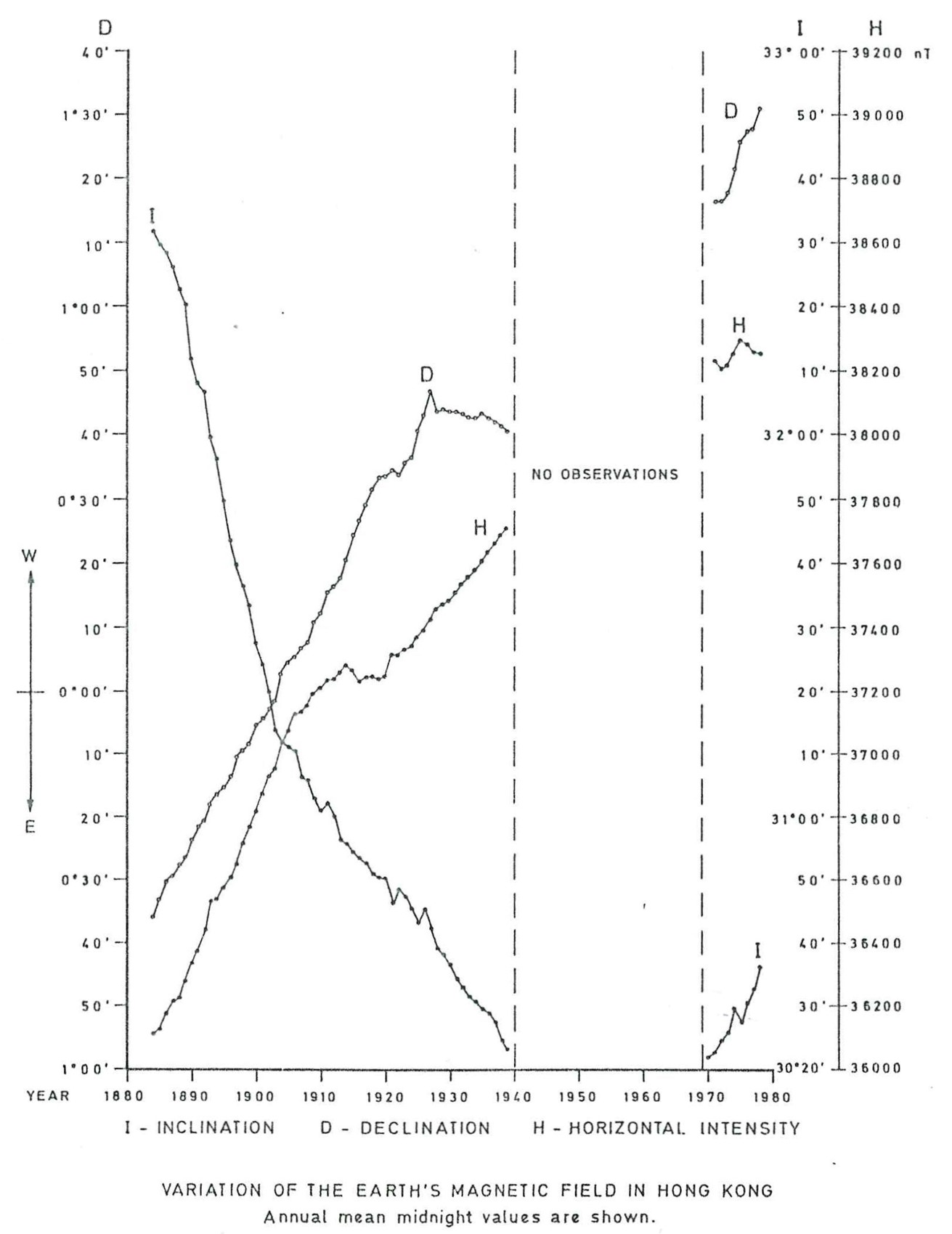
Fig 44: Result of geomagnetic measurement from the establishment of the Observatory to the 1980s.
(8) International affairs
1. Participation in international organisations
The WMO was established on 23 March 1950 to replace the International Meteorological Organization. Hong Kong became a member territory [13] with the Director of the Hong Kong Observatory being the permanent representative. In 1956, in view of a new standards by the International Civil Aviation Organization (ICAO), the Observatory was designated as the Meteorological Authority in Hong Kong for the provision of aviation weather service for international air navigation. In 1968, the Typhoon Committee was established under the United Nation’s Economic and Social Commission for Asia and the Pacific (ESCAP) and WMO with Hong Kong as one of the founding members. In 1997, Hong Kong was returned to China. With the support of the Chinese government, "Hong Kong, China" continues to be a member territory of WMO, laying an important foundation for the Observatory’s continuous participation in international affairs.
At the start of the millennium, the Observatory developed the "Severe Weather Information Center (SWIC)" and the "World Weather Information Services (WWIS)" on behalf of WMO, providing a centralised and authoritative channel for meteorological services around the world to deliver official weather warning and forecast information. In 2011, on behalf of WMO, the Observatory launched "MyWorldWeather", the world’s first mobile app of official weather information. The Observatory was further entrusted by WMO to develop an online version of "International Cloud Atlas (ICA)" with a platform to collect photos globally, and to launch a greatly expanded version of ICA in 2017. In 2018, the Observatory signed a Memorandum of Understanding with WMO and launched SWIC 2.0 that collects warning information from worldwide meteorological services. The Observatory also partnered with the China Meteorological Administration (CMA) to launch the Asian version of the WMO’s Global Multi-hazard Alert System.
Dr LAM Hung-kwan and Mr LAM Chiu-ying, former Directors of the Hong Kong Observatory, had once been elected as Vice-Presidents of the Regional Association II (Asia) of WMO. Mr SHUN Chi-ming, former Director of the Hong Kong Observatory, had been elected as President of the Commission for Aeronautical Meteorology (CAeM) for two terms during 2010-2018. This was the highest position in WMO ever taken by Observatory’s staff. In addition, many staff members of the Observatory have attended various meetings of international organisations such as the WMO, ICAO, the Intergovernmental Panel on Climate Change, the Intergovernmental Oceanographic Commission of UNESCO, the Typhoon Committee, etc. Some staff members served as chairs of committees, coordinators or members of working groups, rapporteurs of workshops, etc., contributing towards meteorology and related sciences in the world.
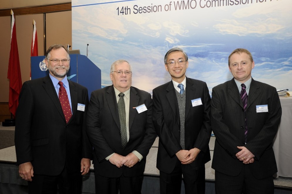
Fig 45: Mr SHUN Chi-ming, the then Director of the Hong Kong Observatory, was elected as the President of the Commission for Aeronautical Meteorology in 2010
In 2018, the Observatory was designated by the WMO as a Regional Specialized Meteorological Centre on Nowcasting in Asia, providing real-time nowcast products, the community version of SWIRLS nowcast system, as well as related professional training to meteorological and hydrological services. The Observatory was also designated to provide an experimental platform for aviation meteorological applications of Doppler LIDAR.
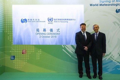
Fig 46: The then Director of the Hong Kong Observatory, Mr SHUN Chi-ming (right), and the Secretary-General of the WMO, Professor Petteri TAALAS (left), officiating at the opening ceremony of the Regional Specialized Meteorological Centre for Nowcasting in October 2018.
2. Cooperation with meteorological services in Mainland China and Macao
The Observatory and the Guangdong Meteorological Bureau signed a cooperation agreement in 1984 on the establishment of an automatic weather station on Huangmaozhou, an island to the south of Hong Kong, and started taking turn to host the "Guangdong-Hong Kong Seminar on Significant Weather" since 1985. From 1989, Macao also joined in this Seminar, which evolved into an annual "Guangdong-Hong Kong-Macao Meeting on Cooperation in Meteorological Operations cum Guangdong-Hong Kong-Macao Seminar on Meteorological Science and Technology".
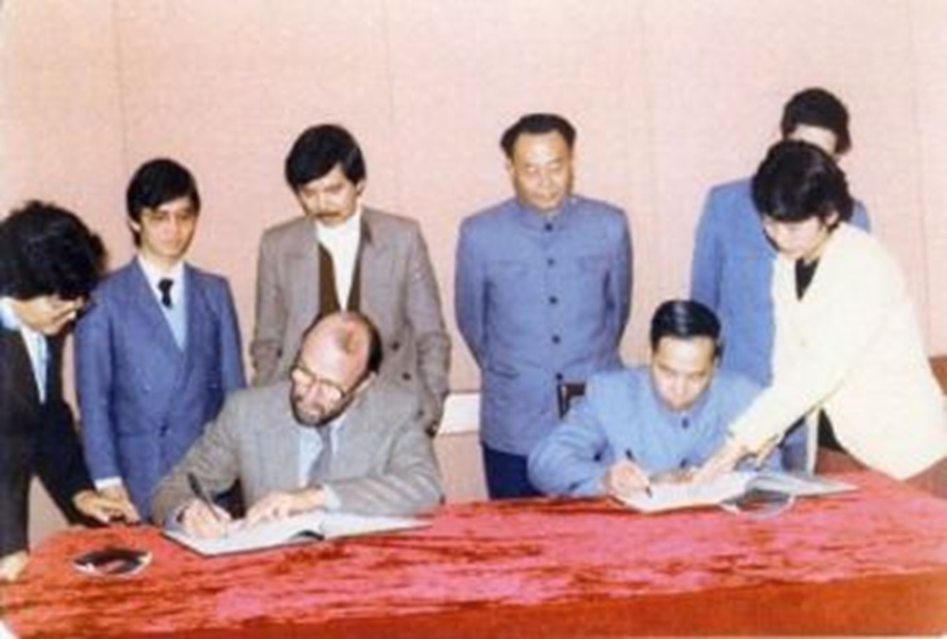
Fig 47: The Hong Kong Observatory signed a cooperation agreement with the Guangdong Meteorological Bureau in 1984
The Observatory signed with the CMA the "Memorandum of Understanding on Long Term Cooperation between the China Meteorological Administration and the Hong Kong Observatory" in 1996 and then the "Arrangement on Long Term Co-operation between the China Meteorological Administration and the Hong Kong Observatory" in 2001.
Recent years saw more frequent interflow among Guangdong, Hong Kong and Macao via numerous seminars and training courses. Apart from sharing real-time observation data and technical knowledge on heat stress measurement, the three parties also joined hands to establish a lightning location network in 2005. In 2011 the "Greater Pearl River Delta Weather Website" was launched, providing the public with the latest weather warnings, forecasts, and real-time observations in the region. In 2019, the three parties collaborated to enhance the "Greater Pearl River Delta Weather Website" to become the "Weather Website for Greater Bay Area". The weather forecasts were further extended to 7 days to provide convenient and reliable weather services for citizens commuting within the area.
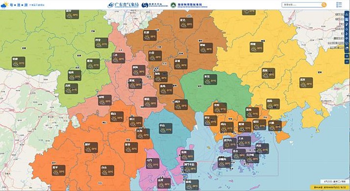
Fig 48. The Weather Website for Greater Bay Area, providing weather warnings, observations, and 7-day forecasts for more than 60 regions in 11 cities in the area.
3. Cooperation with other authorities
In 2018, the Asian Aviation Meteorological Centre (AAMC) jointly established by the Hong Kong Observatory, the Civil Aviation Administration of China (CAAC) and CMA commenced operation. Through the cooperation, the AAMC provides the aviation sector with en-route weather information, so as to meet industry needs and improve aviation safety and efficiency.
Fig 49: The Civil Aviation Administration of China, The China Meteorological Administration and the Hong Kong Observatory signed an agreement to jointly establish the AAMC.
In 2019, following the approval of the Ministry of Natural Resources, the National Marine Environmental Forecasting Centre invited the Observatory to establish a backup centre of the "South China Sea Tsunami Advisory Centre". The Hong Kong Observatory accepted the invitation in January 2020 and started preparatory work, aiming to provide tsunami warning services to neighbouring countries in the South China Sea in future.
Epilogue
After World War II, much has to be done to reinstate the territory. The observatory seized the opportunity to keep on introducing new technologies and new instruments and to strengthen the techniques in observation, prediction and service provision. In recent years, more efforts are paid on innovation, and some innovative technological designs have been patented. Over the years, the Observatory has taken advantage of the development of information technology to constantly expand the scope of the Observatory’s services, from the one-way service provision in the past to personalised and interactive services in recent years.
As a scientific department, the Observatory also provides geophysical services and conducts radiation monitoring work. As far as earthquake monitoring is concerned, the Observatory used long-period seismographs to detect remote earthquakes before the war. The introduction of short-period seismographs and broadband seismographs in 1979 and thereafter greatly strengthened the Observatory’s capability in detecting earthquakes in Hong Kong and beyond. In recent years, the Observatory issues quick earthquake messages to let the public know about locally-felt earthquakes and major tremors around the world. With regard to radiation monitoring, the Observatory has been monitoring the level of nuclear radiation in the atmosphere since 1961. To support the Hong Kong Government's "Daya Bay Contingency Plan", the Observatory launched the "Environmental Radiation Monitoring Plan" in 1987 to monitor the long-term variation in Hong Kong's environmental radiation levels and regularly announce the monitoring results.
Apart from providing services, the Observatory also actively promotes public education. In the early 20th century, the Observatory has been arranging visits for students regularly. Over the years, meteorology and related work have been promoted through lectures, media interviews and programmes, exhibitions, Observatory’s open days, promotional videos, student competitions, publication of book, issuance of stamps and other activities. The Observatory also cooperates with universities and arrange internship and research works at the Observatory for students as a means of cultivation. The Observatory established the "Friends of the Observatory" and a volunteer team in 1996 to strengthen the communication between the Observatory and the public and to raise the public's awareness of weather services. Launched in 2007 and 2013 respectively, the "Community Weather Information Network" and the "Community Weather Observation Scheme" co-organised by the Observatory, universities and non-governmental organisations engage schools, organisations and the general public in making weather observations.
Riding on the achievement in the past, the Observatory will continue to employ the latest technologies, to promote multilateral cooperation based on science and innovation, to strengthen and expand services to better serve the public, and to further enhance the society's capability in natural disaster prevention and response.
References
- According to Mr Lau Tin Chi's recollection of his father, Lau Pak Wa, who worked at the Observatory at the time, the Observatory staff continued to work at the Victoria Peak weather station for a short period of time after evacuation from the Observatory's Headquarters.
- 中里幸雄(2017):《南支那氣象隊的14年兵》(in Japanese only)
- Heywood, GSP, 2015: It Won’t be Long Now: The Diary of a Hong Kong Prisoner of War, 188 pp.
- Annual Report of the Director for the Year Ending 31st March, 1947
- Annual Report of the Director for the Year Ending 31st March, 1949
- 50 Years of Weather Radar Observations in Hong Kong (https://www.hko.gov.hk/tc/press/files/Radar-50years.pdf)
- Windshear refers to the change in winds along the flight direction of aircraft. It can change the buoyancy of aircraft, making it deviate from its intended flight path.
- LIDAR stands for LIght Detection And Ranging. It makes use of pulsed laser to detect movement of particulates in the air.
- ICT stands for information and communications technology.
- Lui, W H, T C Lee, and C M Shun, 2018 : Evolution of the Tropical Cyclone Warning Systems in Hong Kong since 1884, Hong Kong Observatory Technical Note No. 109.
- Annual Departmental Reports, 1955-56, 1959-60 and 1960-61.
- The project was terminated in 1982 owing to lack of funding and manpower.
- Hong Kong signed the “Convention of the World Meteorological Organization” on 11 October 1947, and became a member territory of the World Meteorological Organization on 14 December 1948.
Author:
Dr CHENG Cho-ming, Director of the Hong Kong Observatory
Mr SHUN Chi-ming, Former Director of the Hong Kong Observatory
Dr LEE Tsz-cheung, Senior Scientific Officer, Hong Kong Observatory
January 2022