The need for an observatory
Since 1841, Hong Kong became an important port of trade. In order to ensure smooth port operations and safe navigation of ships, there was a need to provide accurate time service. In the last edition [1] of the Hong Kong Laureate Forum Newsletter, Mr SHUN Chi-ming, former Director of the Hong Kong Observatory (HKO), discussed the important role that astronomical observations played in maritime navigation, especially the need for an accurate clock onboard for determining latitude and longitude at sea. Initially, the time service was provided by the Noonday Gun, which was fired daily at noon. However, by 1861, people began to question the accuracy of this method, and there were calls to provide a more accurate time service based on scientific methods.
Located on the southern coast of China, Hong Kong is susceptible to typhoons between the months of May to November every year. As early as the 18th century, foreign merchants working in Huangpu Port and the ‘Thirteen Factories’ in Guangzhou wrote detailed records of typhoons and their impacts. In July 1841, shortly after the British occupation of Hong Kong, a typhoon almost claimed the lives of Gordon BREMER, Commander-in-chief of the British forces in the area and pivotal figure in the First Opium War, and Charles ELIOT, the first Administrator of Hong Kong (see Fig 1). A few decades later in September 1874, one of the strongest typhoons in Hong Kong’s history caused serious damage across Hong Kong and Macau, killing over 2,000 people in Hong Kong [2] and 5,000 people in Macau – approximately 8% of its population (see Fig 2). In the aftermath of these disasters, there was an urgent need for an organisation that could predict the arrival of storms and issue warnings.
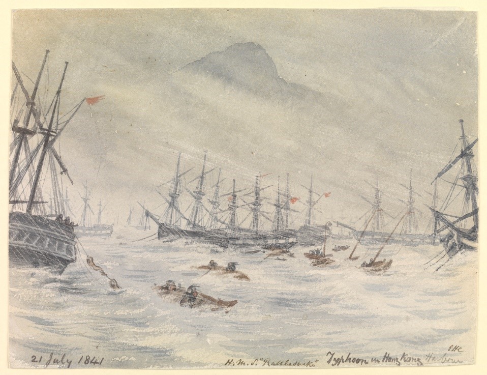
Fig 1: Watercolour painting of 1841 typhoon (courtesy of Royal Museums Greenwich [3] )
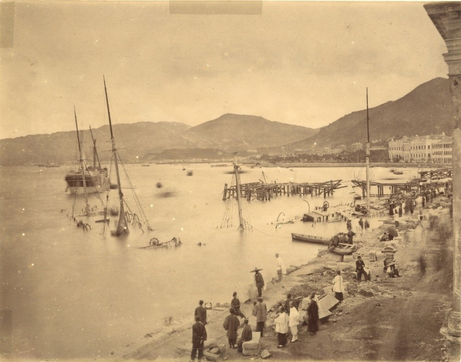
Fig 2: Aftermath of 1874 typhoon in Central (courtesy of Mr Siu Him Fung)
Compared with the time service and typhoon warnings, geomagnetic observations may be unfamiliar to many people, although their role in safe navigation has been no less important. For centuries, compass has been an indispensable tool in maritime and land navigation. However, the north magnetic pole indicated by a compass needle does not correspond exactly to the north geographic pole or ‘true north’, a phenomenon known as magnetic variation/declination. In addition, magnetic declination varies across different locations on the Earth's surface (see Fig 3), and changes over time. In order to meet the need for accurate maritime navigation service, geomagnetic observations became important scientific work. Today, airport runways are still numbered based on their angle from magnetic north (for example, a runway named "07R" is 70 degrees from magnetic north), and the magnetic declination must be known in order to determine the runway’s angle from true north. As the magnetic declination changes over time, it must be measured at least once every few years (see Fig 4).
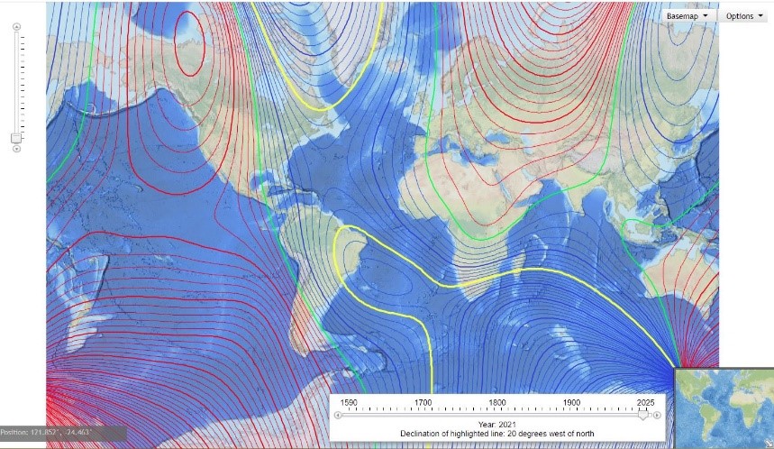
Fig 3: Map of magnetic declination across the world (Courtesy of National Oceanic and Atmospheric Administration [4] )
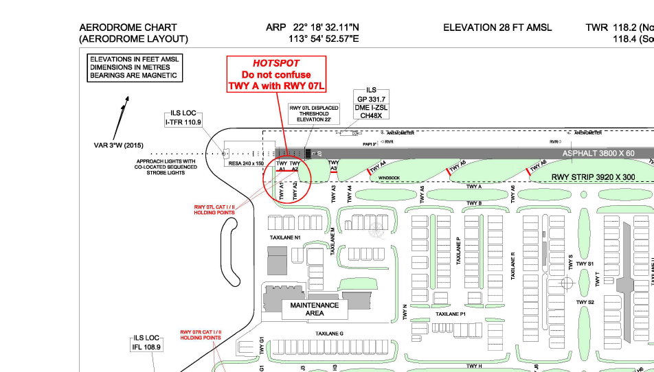
Fig 4: Map of the Hong Kong International Airport. The magnetic declination (‘VAR’) indicated in the upper-left corner was measured at 3°W in 2015. (Courtesy of Civil Aviation Department [5])
Technological advancement for establishing an observatory
Establishment of an observatory relies on relevant technological advancements. In 1829, British Admiral Robert WAUCHOPE installed the world’s first ‘time ball’ in Portsmouth. A time ball was subsequently erected at the Greenwich Observatory in 1833 (see Fig 5). Accurate time measurements were provided with the help of transit instruments at the Portsmouth and Greenwich Observatories.
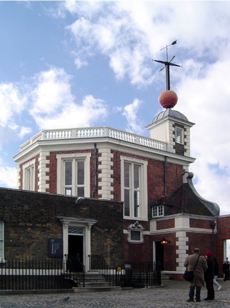
Fig 5: Time ball at Greenwich Observatory (Courtesy of Wikipedia [6] )
The world’s first modern meteorological service – the Meteorological Office – was founded in Britain in 1854 by Vice Admiral Robert FITZROY (see Fig 6). Fitzroy was already famous as the Captain of the HMS Beagle, the British naval vessel aboard which Charles DARWIN served as naturalist during a global voyage from 1831-1836 and wrote the seminal work On the Origin of Species. In the 1850s, Fitzroy arranged for the installation of meteorological instruments on ships to aid weather reporting and barometers at ports for reference by sailors before departure (see Fig 7). The Great Storm of 1859 inspired Fitzroy to develop weather charts and methods for predicting weather, and in 1860 he introduced a system of hoisting storm signals to warn of gales. He also established a network of meteorological observation stations linked via telegraph. These events culminated in the publication of the first public weather forecast in 1861, and laid the foundations for the development of modern weather observation, forecasting and warning services.
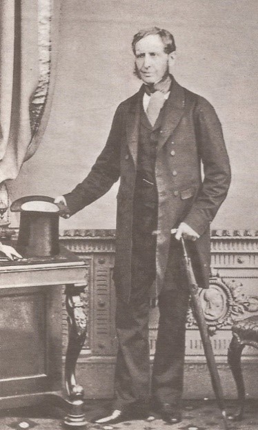
Fig 6: Vice Admiral Robert FITZROY in 1855 (Courtesy of Wikipedia [7] )
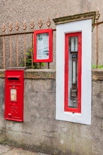
Fig 7: ‘Fitzroy fisheries barometer’ at Stromness Port, Orkney. (Courtesy of Wikipedia [7] )
The development of modern meteorological facilities and services in China dates back to the unequal Treaty of Nanking, signed by the Qing government in 1842. In addition to the cessation of Hong Kong to the British, China was also forced to open five ‘treaty ports’ to foreign trade. In order to ensure the collection of taxes on maritime trade amidst the turmoil of the Taiping Rebellion (a civil war in southern China), the Qing government agreed to establish the Imperial Maritime Customs Service under the leadership of a British-appointed Inspector-General in 1854. The second Inspector – General Robert HART played a pivotal role in the installation of meteorological facilities in China. Firstly, in 1869 he started to establish meteorological stations equipped with Western meteorological instruments at various locations throughout China, especially at ports and lighthouses – an important measure designed to address the growing need for safe maritime navigation. This coincided with the gradual expansion of the telegraph network within China, especially in coastal cities. For example, the laying of the Hong Kong-Shanghai and Hong Kong-Singapore submarine cables were completed in 1870 and 1871 respectively (see Fig 8). The network of meteorological stations established by Hart played a key role in the development of the Xujiahui Observatory in Shanghai, the HKO and other meteorological services throughout East Asia.
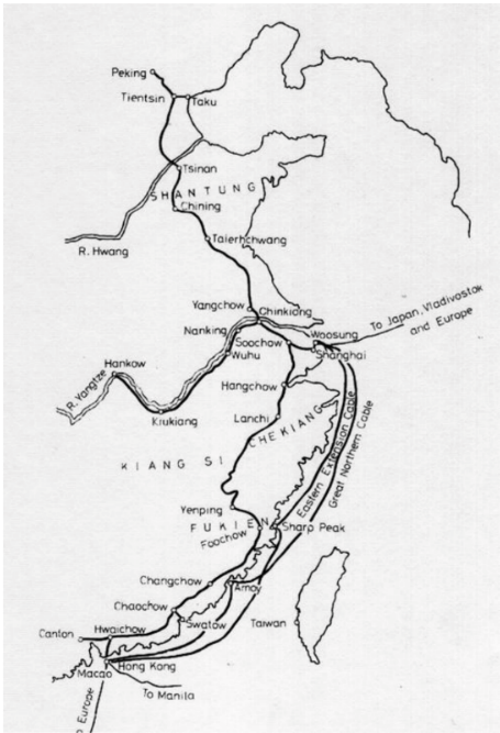
Fig 8: Network of telegraph cables to/from Hong Kong, c. 1884 (Courtesy of Hong Kong University Press [8] )
Meanwhile, in 1834, Europe started to develop a network of geomagnetic observatories under the leadership of famous physicists Carl F GAJSS and Wilhelm E WEBER. The network was subsequently expanded to other parts of the world. In 1849, Russia established a geomagnetic and meteorological observatory in Beijing, and in 1874, the Xujiahui Observatory (also known as Zikawei Observatory) in Shanghai started to make geomagnetic observations. These developments paved the way for the establishment of geomagnetic observation in Hong Kong.
Plans for a new observatory
In the light of these developments, in 1877 the Surveyor General [9] John M PRICE submitted a plan for a new observatory to the Hong Kong colonial government. The Observatory was to be built on a small hill called Mount Elgin in Tsim Sha Tsui, Kowloon. Its primary purpose was to provide accurate time service via a time ball, which would enable calibration of marine chronometers onboard incoming ships. Previously, such chronometers had to be sent to specialist technicians for calibration. Although Price’s plan received the backing of Admiral Alfred P RYDER, Commander-in-Chief of the China Station, the then Governor of Hong Kong John P HENNESSY, however, did not submit the plan to the Colonial Office in London. In 1879, the British astronomer Dr Warren DE LA RUE presented the Colonial Office with another observatory proposal on behalf of the Royal Society's Kew Committee. This proposal was subsequently improved and revised in 1881 by Hennessy’s Aide-de-camp, Major Henry S PALMER, and had been considered as the blueprint for the construction of the HKO. According to the proposal, the Observatory was to provide three key services: meteorological observations, time service, and geomagnetic observations. The Kew Committee believed that the Observatory would be in a favourable location for the study of meteorology in general and typhoons in particular, as it would be able to complement existing observatories in Manila and Shanghai. However, Palmer’s revised proposal was considerably more costly than Price’s original plan, and the Colonial Office did not approve the funding for the project. Following Hennessy’s departure from office, the proposal was revised again by Price with significantly downsized scale and budget, and in 1882, the Colonial Office approved the construction of the HKO on Mount Elgin in Tsim Sha Tsui, Kowloon. In total, it took almost five years for Price’s proposal to receive approval. During this period, to meet societal needs, the Harbour Master [10] arranged in August 1877 for the Harbour Master’s Office to hoist storm signals, and for the marine police hulk to hoist similar signals and to fire a gun to warn of incoming storms. In August 1882, the Harbour Master also arranged for the provision of time service via a time ball on board the HMS Victor Emmanuel.
Establishment of the HKO
Dr William DOBERCK (see Fig 9) was appointed as the first Director of the HKO (also known as the Government Astronomer) on 2 March 1883, and arrived in Hong Kong with his First Assistant Frederick G FIGG on 28 July. The HKO was established in the same year, and became a new government department with four staff: the Director, First Assistant, Second Assistant and Chinese Clerk. The headquarters of the Observatory is built on Mount Elgin and occupied an area of 1.62 hectares (4 acres) at an altitude of approximately 32 metres above sea level. Completed in 1883, the two-storey main building was built in the Victorian-Colonial style at the eastern end of the hill (see Fig 10 and Fig 11).
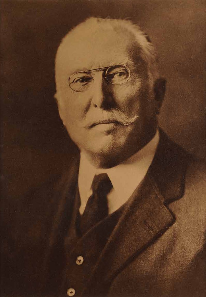
Fig 9: Dr William DOBERCK, first Director of the HKO. (Courtesy of Hong Kong Observatory)
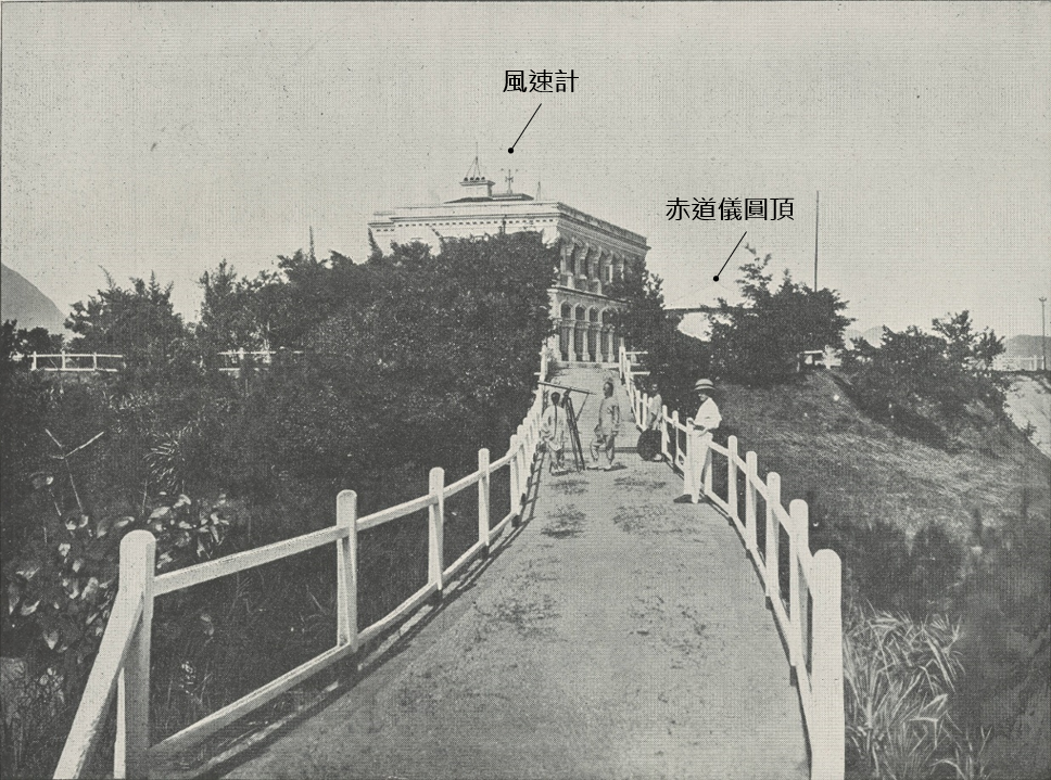
Fig 10: Main building of the HKO, photographed in 1893 or earlier. Visible in image: (1) Beckley anemometer on the roof of the main building; and (2) Dome for housing the Observatory’s equatorial telescope. (Courtesy of Mr SHUN Chi-ming)
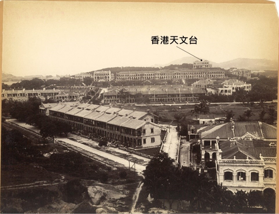
Fig 11: The HKO on Mount Elgin, photographed between 1902-1905. (Courtesy of Mr SHUN Chi-ming)
The original layout of the Observatory can be inferred by comparing an enlarged version of Fig 11 (see Fig 12) with a nautical chart of the surrounding area (see Fig 13). In addition to the main building and the thermometer shed in front of it, the photograph also shows a number of important instruments that are no longer in existence today. The first of these is the transit room – followers of the HKO’s ‘Cool Met Stuff’ programme [11] will know that this building once housed a transit telescope that marked the precise location of the Hong Kong Meridian. The Observatory was also once home to an equatorial telescope, although neither of the original telescopes remain on site today. The white dome that housed the equatorial telescope can be seen in Fig 10. Fig 12 also depicts a magnetic hut, which contained instruments for taking geomagnetic measurements. Fig 14 shows the Observatory’s location atop Mount Elgin on the Kowloon Peninsula. Thanks to the unobstructed views over Victoria Harbour, the hilltop location was ideal for making meteorological observations.
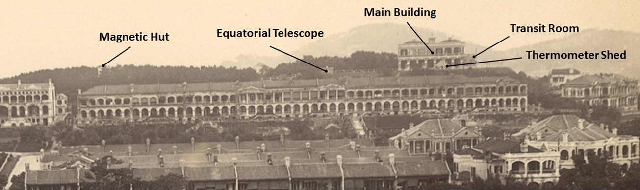
Fig 12 (enlarged version of Fig 11): (1) main building of the Observatory; (2) thermometer shed; (3) transit room; (4) equatorial telescope; and (5) magnetic hut. (Courtesy of Mr SHUN Chi-ming)
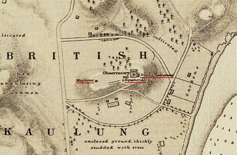
Fig 13: Nautical chart from 1886-1887 showing the location of the HKO, including its major instruments (from right to left) labelled as "transit instrument", "equatorial" and "magnetic" which correspond respectively to (3), (4) and (5) in Fig 12. (Courtesy of Mr SHUN Chi-ming)
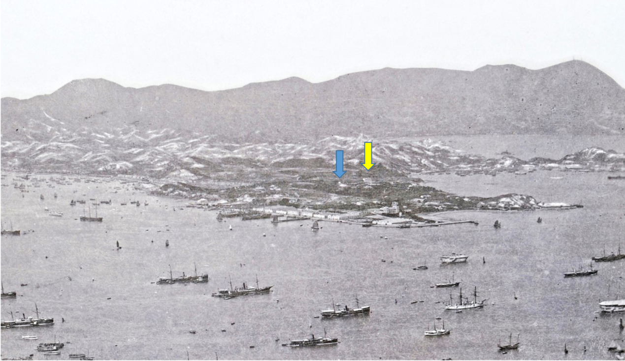
Fig 14: Photograph of the Kowloon Peninsula dated 1886 showing the location of the Observatory’s main building (yellow arrow) and magnetic hut (blue arrow) atop Mount Elgin. (Courtesy of Mr SHUN Chi-ming)
Early development and services
(1) Meteorological observations and recordsFollowing the formulation of the Instructions for Making Meteorological Observations Prepared for Use in China by Dr Doberck in 1883 [12] , the Observatory started to make routine surface meteorological observations on 1 January 1884. A wide variety of measurements were taken, including pressure, temperature, wind speed, wind direction, cloud type, cloud cover, cloud’s direction of motion, rainfall and sunshine duration. Relative humidity was calculated from the dry- and wet-bulb temperature readings using humidity tables. Around 1889 or earlier, the Observatory started to use an Indian-style thermometer shed made from palm leaves and bamboo mats, which helped to improve air circulation around the thermometers and prevent overheating in the summer, as was often the case with the conventional Stevenson screens. This kind of temperature shed is still in use today. The location of the Observatory’s facilities and instruments pinpointed in Fig 15. Fig 16 and 17 show earlier generations of the Observatory’s temperature shed. From 1884, the observations made at the Observatory headquarters and other meteorological stations [13] were published annually in Meteorological Results, Part I, Surface Observations. From 1 January 1884, the HKO took over responsibility from the Harbour Master’s Office for the preparation and publication of the China Coast Meteorological Register, which was published in Hong Kong’s major newspapers (see Fig 18). A number of revisions were also made to the content. In addition, meteorological observations made at the Observatory headquarters was published in the Meteorological Register, which also appeared in the major newspapers. The meteorological reports from Shanghai, Xiamen (Amoy), Manila and Nagasaki which were used to compile the China Coast Meteorological Register were provided free of charge by two telegraph companies, Eastern Extension [14] and Great Northern [15] .
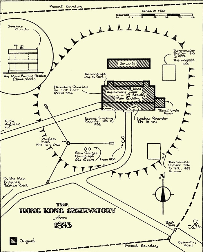
Fig 15: Location of the Observatory’s facilities and instruments from 1884 to 1950, including the transit circle room, thermometer shelter, thermograph, Beckley & Dines anemometers, sunshine recorder, rain gauges, pluviograph and wireless mast. (Courtesy of the HKO)
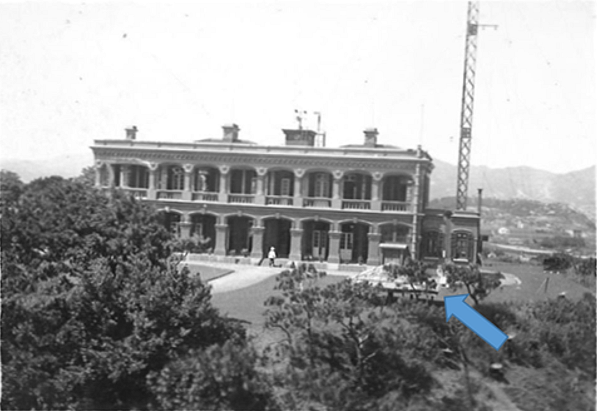
Fig 16: Photograph of the Observatory’s main building in the 1930s. The blue arrow shows the location of the thermometer shed; the second-generation signal mast can be seen behind the transit room. (Courtesy of family of Mr GSP HEYWOOD)
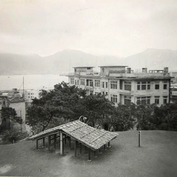
Fig 17: The thermometer shed in the 1950s. (Courtesy of the HKO)
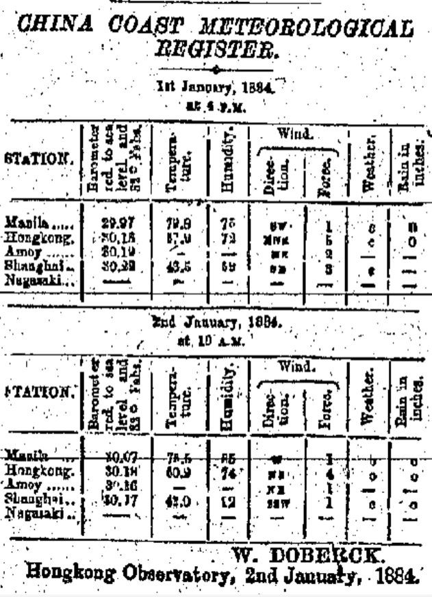
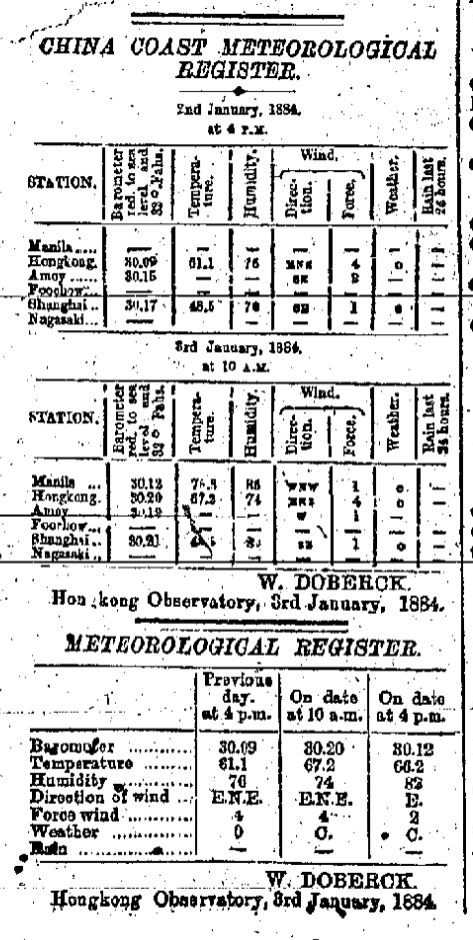
Fig 18: The Observatory’s first issue of the China Coast Meteorological Register (left) and Meteorological Register (right) published in the Daily Press. (Courtesy of Hong Kong Central Library)
(2) Time serviceIn the early years, the HKO used a 3-inch transit telescope (Fig 19) and a six-inch Lee Equatorial telescope (Fig 20) to make astronomical observations. The transit telescope was primarily used to determine the local time at the Hong Kong Meridian [16] , while the equatorial telescope was used for observations of Jupiter and its moons, Saturn and its rings, and double stars, as well as the 1910 passage of Halley's Comet. In 1884, the HKO built a time ball tower at the Marine Police Headquarters in Tsim Sha Tsui, which was situated on a small hill next to the harbour (Fig 21). Suspended from the top of a mast, the time ball was six feet in diameter and provided an accurate time service for ships visiting Hong Kong.
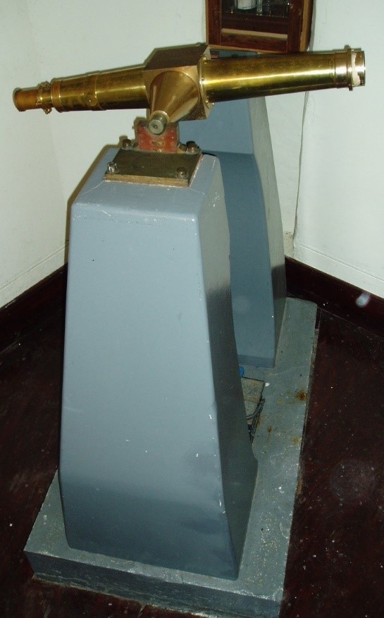
Fig 19: Three-inch transit telescope manufactured by Troughton & Simms. The HKO used this type of transit circle to provide the time service, although the original was lost during the Second World War. (Courtesy of Orwell Park Observatory [17] )
Fig 20: Six-inch Lee Equatorial telescope, which was on loan by the Greenwich Royal Observatory to the HKO in 1885 for astronomical observations. The telescope was returned to the Greenwich Royal Observatory in 1914 and is currently held by the British Science Museum. (Courtesy of Mr SHUN Chi-ming)
Fig 21: First-generation time ball tower at the Marine Police Headquarters in Tsim Sha Tsui (photograph from 1886). The signal mast for hoisting storm signals can be seen adjacent to the time ball tower. (Courtesy of Mr SHUN Chi-ming)
The time ball tower entered into service on 1 January 1885. The time ball was raised half way up the mast at 12:55 pm each day. It was then raised to the top of the mast at 12:57 pm before being dropped at exactly 1 pm via an electric circuit that was connected to the Observatory’s clock. The average error was less than 0.2 seconds – remarkably accurate for the time. The time ball tower was subsequently relocated to nearby Blackhead Point (also known as Signal Hill) in January 1908 (see Fig 22). On 1 September 1918, following the development of wireless radio technology and the establishment of a new wireless station at Cape D'Aguilar, the HKO started to broadcast time signals over the radio. On 1 January 1920, the HKO started to provide time signals at night using three flashing white lights on the wireless mast at its Headquarters between 8:56 pm and 9:00 pm, and changed the schedule of dropping of the time ball to 10 am and 4 pm daily [18] .
After almost half a century, the time ball service was finally replaced by wireless broadcasts on 1 July 1933.
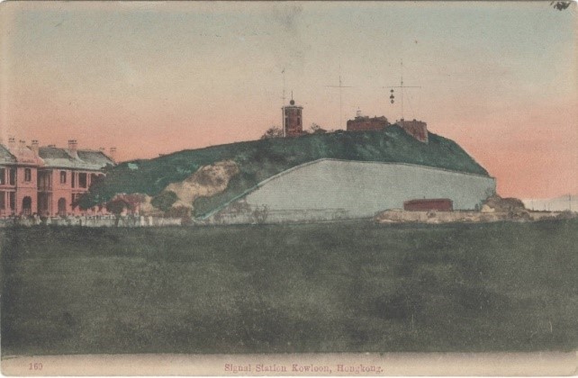
Fig 22: The second-generation time ball tower at Blackhead Point in Tsim Sha Tsui, c. 1910. The signal mast for hoisting storm signals can be seen adjacent to the time ball tower. (Courtesy of Mr SHUN Chi-ming)
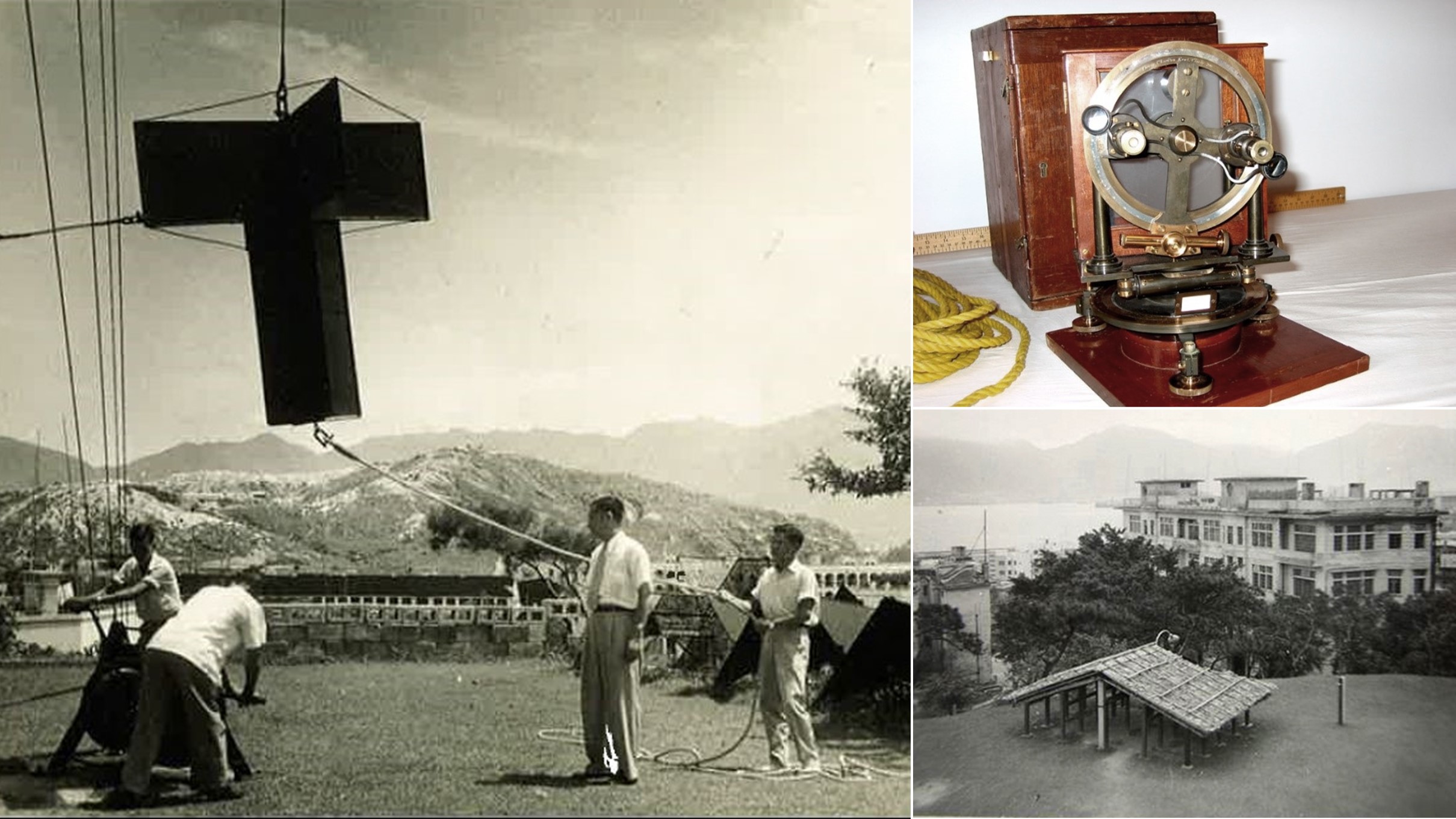
(3) Geomagnetic observationsIn 1884, the Observatory started to make regular geomagnetic measurements using a magnetometer and dip circle (see Fig 23 and Fig 24). A wide range of measurements were taken, including horizontal and vertical force, variation/declination and dip/inclination, and records were kept until 1939. Between 1884 and 1927, measurements were made at two observation points within the Observatory headquarters. In order to reduce interference from adjacent buildings, the geomagnetic station was relocated to Au Tau in northwestern part of the New Territories in 1928. Unfortunately, the Au Tau geomagnetic station ceased to operate following the Japanese invasion of Hong Kong on 8 December 1941, and two members of the Observatory’s staff (Mr GSP HEYWOOD and Mr L STARBUCK) were captured by Japanese forces while attempting to remove instruments from the station. The instruments and station were subsequently destroyed, and Heywood and Starbuck were interned at Sham Shui Po Prisoner-of-War (POW) Camp until the end of the Second World War. Heywood wrote a diary of his experiences at the POW Camp [19] .
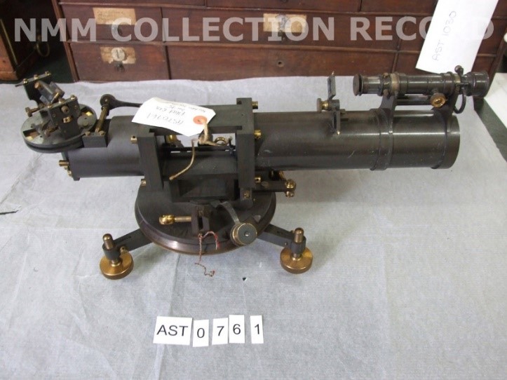
Fig 23: A Kew-Pattern Unifilar Magnetometer. The HKO used this kind of instrument to measure horizontal force and variation/declination. (Courtesy of Royal Museums Greenwich [20])
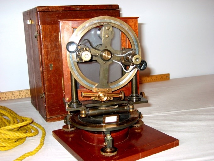
Fig 24: A Dover Dip Circle. The HKO used this kind of instrument to measure dip/inclination. (Courtesy of Department of Natural Resources Canada [21])
(4) Storm warning systemOne of the Observatory’s main missions was to establish a warning system for tropical cyclones. In 1884, Hong Kong adopted a visual storm warning system with four red signals to alert ships in the harbour to nearby tropical cyclones and their direction relative to Hong Kong. The directions were given via a drum (east), downwards cone (south), ball (west) or upwards cone (north). This signal system was known as the Non-Local Storm Signal Code [22] . In 1890, a set of black signals was added, which indicated that the centre of the tropical cyclone was less than 300 miles away from Hong Kong. The red signals indicated that the storm was more than 300 miles away. In 1904, the signals were further enhanced, with the direction of the tropical cyclone given in eight-point compass directions. After 1906, the system was changed to conform to the storm warning system used in other Chinese coastal ports, including the China Coast Code, which was used from 1906 to 1917 (see Fig 25). The period between 1904 and 1906 was one of significant change, with more than one storm warning system in use.
In the early years, the general public had to rely on the typhoon gun, which was fired at the Marine Police Headquarters in Tsim Sha Tsui to warn of imminent gale force winds. However, in the aftermath of the 1906 Hong Kong Typhoon that claimed over 10,000 lives, the typhoon gun was replaced by explosive bombs in 1907 – when a tropical cyclone was approaching, the Marine Police Headquarters would fire three bombs and hoist a black cross signal above all the non-local signals. This was the predecessor of the Hurricane Signal No 10. The last typhoon bomb was set off in 1937 during the passage of the 1937 Great Hong Kong Typhoon.
In 1890, night signals were introduced using two lanterns, which were hoisted at the Marine Police Headquarters. Following the 1906 Hong Kong Typhoon, this system was replaced with three vertical lights in green and red, which were mounted at the Marine Police Headquarters and repeated at the Harbour Master’s Office and on board HMS Tamar. When hurricane force winds were expected, the night signal would be red-green-red, which was the predecessor to the night signal for Hurricane Signal No 10 in modern-day Hong Kong.
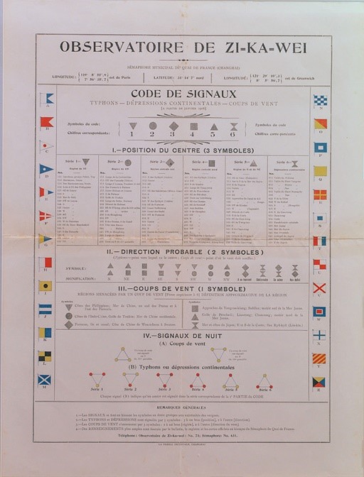
Fig 25: French edition of the China Coast Code (Courtesy of Xujiahui Observatory, Shanghai)
In 1917, the HKO overhauled its storm signal system with the introduction of new local and non-local storm signal codes. The non-local signals were in use concurrently with the local signals until 1961.
1. Non-local signalsOn 1 July 1917, Hong Kong introduced new non-local storm signals [22] . At the request of the Chamber of Commerce, the China Seas Storm Signal Code was introduced on 1 June 1920 (see Fig 26). The non-local storm signals were revised in 1931 and 1950 based on the recommendations of regional conferences (including the Conference of Directors of Far Eastern Weather Services held in Hong Kong in 1930).
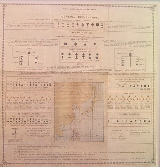
Fig 26: Poster of the China Seas Storm Signal Code (Courtesy of Xujiahui Observatory, Shanghai)
2. Local signalsNew numbered local storm signals [22] were introduced on 1 July 1917. This numbered signal system was the predecessor to Hong Kong’s current tropical cyclone warning system. Its main purpose was to warn residents of the threat of winds associated with tropical cyclones. According to this new system, the local storm conditions were rated on a scale of 1 to 7 (see Fig 27). Signals 2 to 5 indicated that gales were expected from the north, south, east or west respectively. Signal 6 warned of increasing gale-force winds, and signal 7 indicated that hurricane force winds were expected. This local signal system also included new night signals (see Fig 27), which remained in use until the end of 2001 when the last signal station was decommissioned.
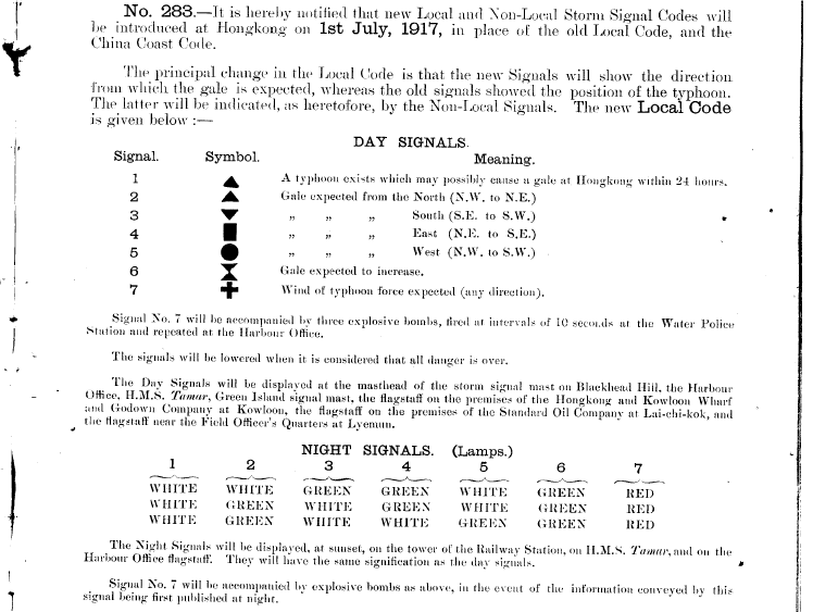
Fig 27: The Hong Kong Government Gazette of 15 June 1917 announcing the introduction of the new local storm signals21 on 1 July. (Courtesy of HKU Libraries [23] )
The local storm warning system evolved to meet the needs of Hong Kong’s society. In 1931, the system was extended to ten signals (see Fig 30) based on the recommendations from the Conference of Directors of Far Eastern Weather Services held in Hong Kong in 1930 (see Fig 28 and Fig 29). Signals 2 and 3 indicated that strong winds were expected from the southwest and southeast respectively. Signal 4 was a non-local signal that was not used in Hong Kong, while signals 5 to 8 warned of gale force winds from the northwest, southwest, northeast or southeast. Signal 9 indicated increasing gale force winds, and signal 10 warned of hurricane force winds. Signals 2, 3 and 4 were used intermittently, and were subsequently abolished in the latter half of the 1930s.
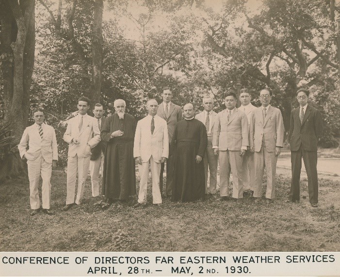
Fig 28: Participants of the Conference of Directors of Far Eastern Weather Services held in Hong Kong in 1930 (TF CLAXTON, Director of the HKO (5th from left); the Rev. Father Louis FROC, SJ, Director of the Xujiahui Observatory (4th from left); the Rev Father Miguel SELGA, SJ, Director of the Manila Observatory (7th from left); SW SUNG, representative of Chinese meteorologist Cochin Chu (4th from right); Pingjan TSIANG, Director of Qingdao Observatory (2nd from right); and YC SHEN, Director of Dongsha Observatory (far right)). (Courtesy of the HKO)
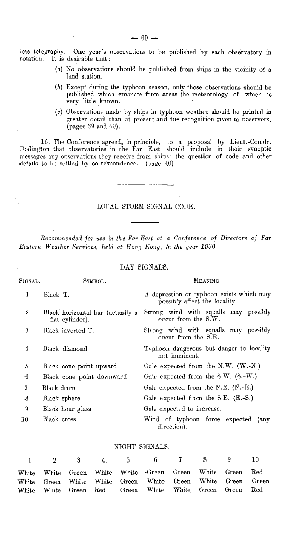
Fig 29: The local storm signals [22] recommended by the Conference of Directors of Far Eastern Weather Services, including day and night signals. (Courtesy of the HKO)
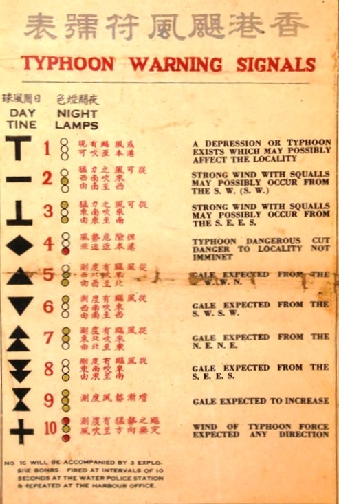
Fig 30: The No 1 to No 10 signal system used in Hong Kong from 1931 to 1935. (Courtesy of Mr Ricky YAM)
3.History of hoisting storm signals at the Observatory headquartersLocal and non-local signals were used concurrently for many years. The signals were displayed in numerous key locations, including the Marine Police Headquarters, Kowloon Wharf, and Signal Hill (see Fig 31) in Kowloon, the Harbour Master’s Office on Hong Kong Island, Green Island, and HMS Tamar in Victoria Harbour. The number of locations was gradually expanded to include other districts. Following the adoption of the China Seas Storm Signal Code (see Fig 26) for non-local signals in 1920, the mast head at Signal Hill was no longer used for local signals, and was instead used to display the time signal of the China Seas Storm Signal Code (see Fig 32). This triggered the need to transfer local signals to another location. Based on the recommendations of the Director of the HKO at the time, local signals were transferred to the first-generation wireless mast at the Observatory headquarters (see Fig 33 and Fig 15). Local night signals started to be displayed on the Observatory’s wireless mast on 3 October 1919, with day signals commencing on 1 June 1920. Night signals were also displayed at the Clock Tower of Kowloon Railway Station, the Harbour Master’s Office and HMS Tamar. In 1933, the wireless mast was moved from the southwest to the northeast of the main building (see Fig 34) to make way for the director’s quarters. As the Observatory’s headquarters were situated some way from Victoria Harbour, the height of the signal used for local storm signals was increased to eight feet (see Fig 35). To make way for the construction of a new building, the wireless mast northeast of the main building ceased operation on 1 July 1978 and was later dismantled. This marked the end of the hoisting of storm signals, displaying of the local night signals and providing time signals at night using flashing lights at the Observatory Headquarters.
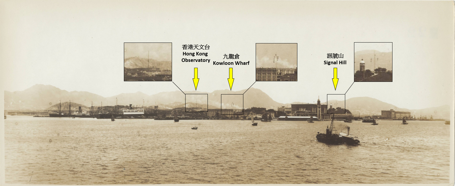
Fig 31: A panoramic view of Tsim Sha Tsui waterfront in the late-1920s to early 1930s showing three different locations where tropical cyclone signals were hoisted: the HKO (local signal), Kowloon Wharf (non-local signal) and Signal Hill (non-local signal). (Courtesy of Mr SHUN Chi-ming)
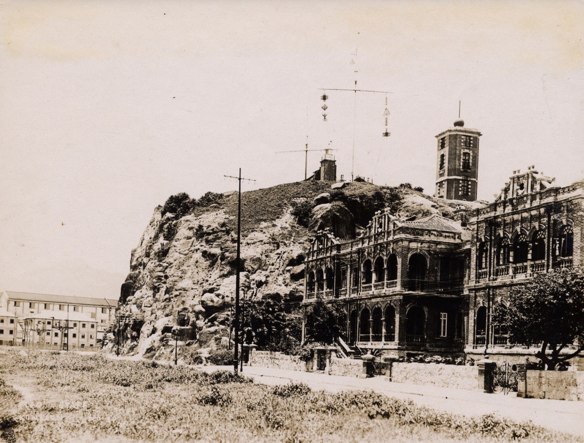
Fig 32: China Seas Storm Signal Code hoisted on Signal Hill in the 1920s. The symbol at the mast head showed the time signal of the storm signal. (Courtesy of Mr SHUN Chi-ming)
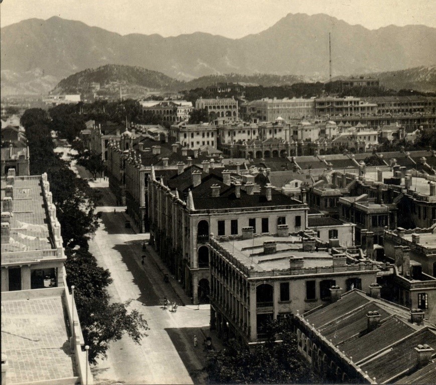
Fig 33: Photo of Tsim Sha Tsui from late 1920s showing the first-generation wireless mast at the Observatory headquarters. (Courtesy of Mr SHUN Chi-ming)
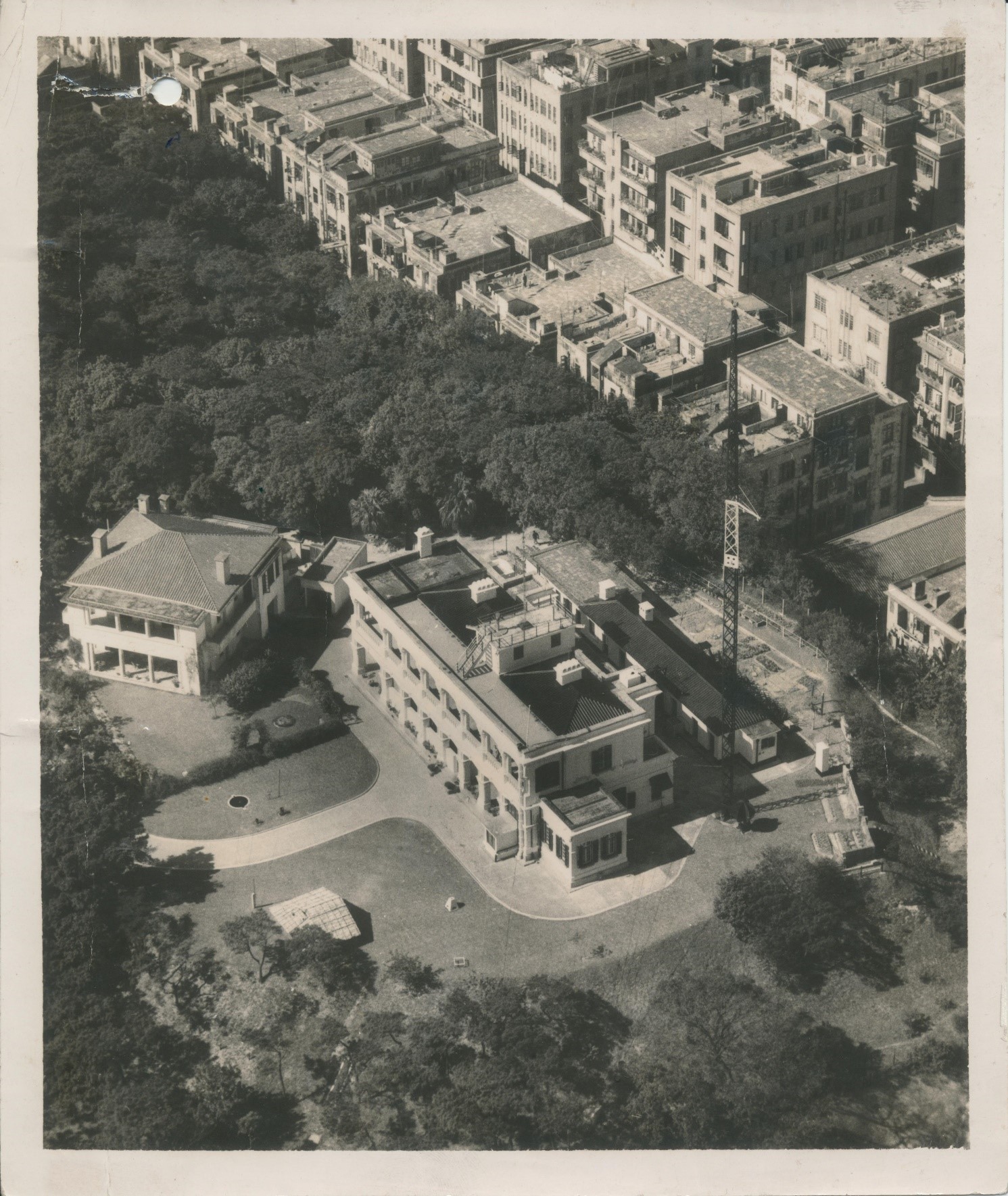
Fig 34: Photo from 1951 showing the second-generation wireless mast at the Observatory headquarters. (Courtesy of the HKO)
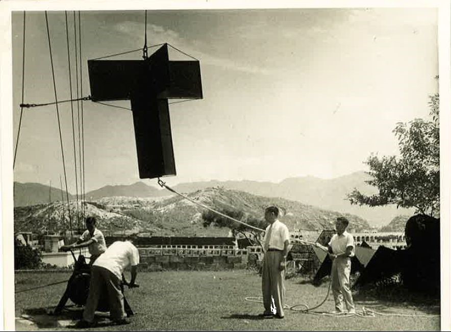
Fig 35: Hoisting of Standby Signal No 1 at the Observatory headquarters in the 1930s under the supervision of Mr GSP HEYWOOD (second from right). The large size of the signal is clearly visible in the image. (Courtesy of family of Mr GSP HEYWOOD)
(5) Weather services and reportsThe HKO was founded clearly to serve the shipping community. In addition to issuing storm warnings to ships, one of the Observatory’s most important services was the publication of the China Coast Meteorological Register in Hong Kong’s major newspapers (see Fig 18). The China Coast Meteorological Register has a long history, and was first published by the Harbour Master’s Office on 5 August 1873 (see Fig 36) following Hong Kong’s connection to the telegraph network in 1870 and 1871. On 2 January 1884, the HKO took over responsibility for the publication of the China Coast Meteorological Register (see Fig 18) and made a number of revisions to the contents. These included replacing "wet thermometer" with "humidity", simplifying certain readings (e.g. merging the two same-day temperature readings into one reading) and the listing of meteorological records for Nagasaki. From 10 January 1884, the China Coast Meteorological Register started to include information similar to the "General Situation" nowadays (see Fig 37). In the event of a typhoon, information on the typhoon’s development would also be stated here.
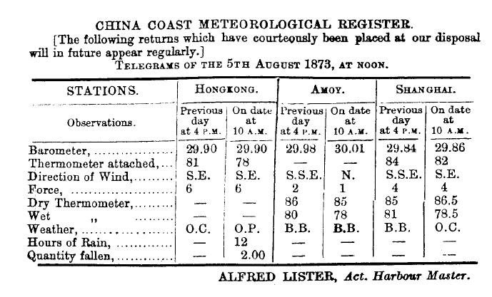
Fig 36: The China Coast Meteorological Register published by the Harbour Master’s Office in The China Mail on 5 August 1873. (Courtesy of Mr KY MA)
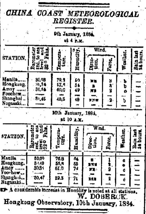
Fig 37: The China Coast Meteorological Register dated 10 January 1884 published in The Daily Press contains the following weather situation: "A considerable increase in Humidity is noted at all stations". (Courtesy of Hong Kong Central Library)
In the years immediately after the Observatory was founded, the publication of meteorological information was slow and cumbersome. The China Coast Meteorological Register had to be sent by messenger each day to the naval headquarters, Harbour Master’s Office, telegraph companies and the three English newspapers. Messages received via telegraph from overseas also had to be delivered to the Observatory by messenger. It was not until 1890 that the Observatory was connected to the telegraph network, allowing it to telegraph its China Coast Meteorological Register and Meteorological Register directly to telegraph companies and the Harbour Master’s Office, who could then display the latest weather reports on their notice boards. Sailors could also contact the Observatory via the telegraph companies and obtain free weather information. In addition, the Observatory was able to receive weather reports via telegraph from the signal station at Victoria Peak and from the lighthouse on Gap Rock built subsequently.
In 1892, the Observatory made another step forward with the appointment of Ms Annie DOBERCK (younger sister of Director Dr William DOBERCK) as Assistant Meteorologist. As the Observatory’s first female meteorologist, Ms Annie DOBERCK was responsible for issuing weather forecasts, the China Coast Meteorological Register and Meteorological Register, as well as boarding ships in the harbour to collect meteorological records from ship logs for meteorological analysis and the preparation of marine climatological charts. As the predecessor to today’s Port Meteorological Officer, she also liaised with ship captains, answering weather-related questions and establishing the basis for a cooperative relationship. The preparation of the marine climatological charts required the collection of large numbers of meteorological records from ships, as well as extensive analyses and calculations. Between 1893 and 1911, Ms Annie DOBERCK compiled almost 420,000 meteorological records, and in 1914 she completed her first marine climatological chart before retiring in 1915.
According the Director’s annual report, from 1892 onwards the HKO started to forward on a daily basis the China Coast Meteorological Register, which included a weather forecast for the following 24 hours, to the newspapers in time for insertion in the supplementary edition that was issued around noon. However, the annual report also mentioned that these arrangements were not always followed, with none of the newspapers regularly publishing the forecast by the same evening or even the following morning. Therefore it is apparent that such arrangement faced difficulties initially. On 14 October 1893, the Observatory started to print additional copies of the China Coast Meteorological Register, which were delivered to captains free of charge by the Harbour Master’s Office. Although the 1892 Annual Report mentioned that the China Coast Meteorological Register contained a 24-hour weather forecast produced by a dedicated member of staff, it was not until 21 January 1895 that the word ‘forecast’ appeared in the publication (see Fig 38), a subject that is worthy of further study.
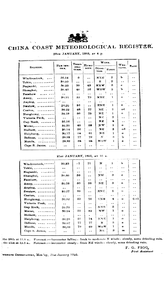
Fig 38: The China Coast Meteorological Register dated 21 January 1895, in which the word ‘forecast’ could be seen. (Courtesy of the HKO)
On 23 July 1906, the Observatory modified the China Coast Meteorological Register to include a 24-hour forecast for various regions (see Fig 39), covering an extensive area from the Taiwan Strait in the east to Hainan Island in the west, which laid the foundations for the subsequent provision of the Marine Forecast for shipping and Weather Information for South China Coastal Waters.
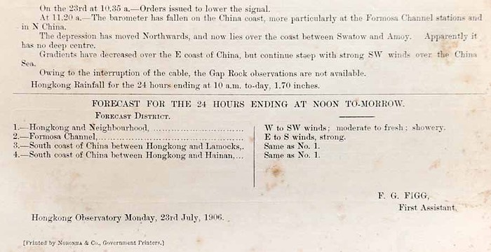
Fig 39: The China Coast Meteorological Register dated 23 July 1906, which included a 24-hour weather forecast for four different regions. (Courtesy of the HKO)
June 1909 was another milestone for the Observatory’s meteorological services: copies of the daily weather charts covering the East Asian region were produced and displayed at the notice boards at the Harbour Master’s Office, Blake Pier and the Star Ferry Pier for reference by the general public (see Fig 40). Over the next few years, the China Coast Meteorological Register (subsequently renamed as the Daily Weather Report) and the 24-hour regional weather forecasts were used extensively by local and even overseas institutions. In order to meet the growing demand, the Daily Weather Report was made available to private companies and individuals on 1 January 1914 for an annual subscription fee of HK$10. In the same year, thanks to lithographic technologies, the Observatory was able to print copies of its daily weather charts, which previously had to be drawn by hand. In 1917, private companies and individuals were able to obtain copies of the daily weather charts for an annual subscription fee of HK$36.
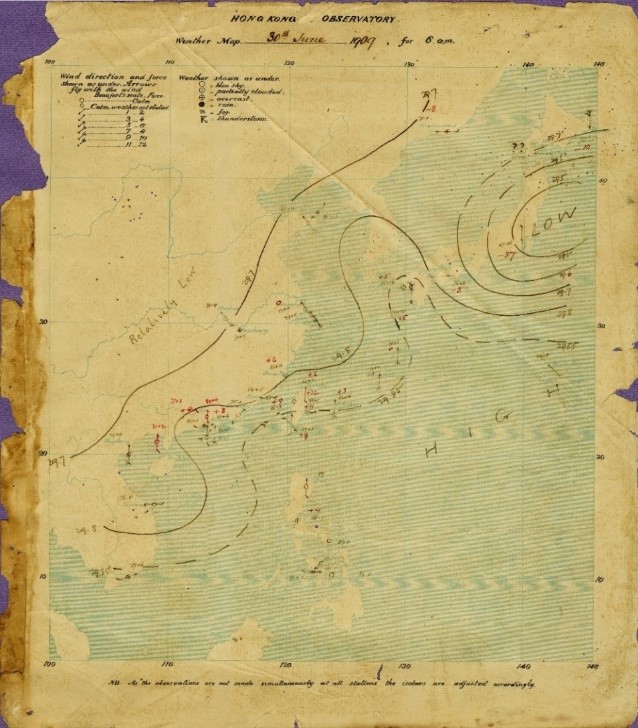
Fig 40: The Observatory's earliest surviving weather chart, issued at 6 am on 30 June 1909. (Courtesy of the HKO)
The development of the Observatory’s services relied heavily on technological advancement. Even though radio technology emerged at the end of the 19th century, its use in Hong Kong was initially restricted to the military and cooperation between the military and the Hong Kong Government could not be taken forward. Following two devastating typhoons in 1906 and 1908, the Hong Kong Government was keen to improve the typhoon warning system. In 1908, after renewed calls to adopt wireless communications technology [24] , the Observatory started to receive radio reports with meteorological observations from British naval ships. This was followed by the establishment of a new wireless station in 1915 at Cape D'Aguilar at the southeastern tip of Hong Kong Island, which enabled the Observatory to issue daily weather reports and typhoon information to passing ships. Weather forecasts and typhoon information were telegraphed from the HKO to the wireless station at Cape D'Aguilar using Morse code for dissemination to ships at 1 pm. From 1919 to early 1920, the dissemination frequency was increased to twice per day. From September 1918, the Observatory also disseminated two daily time signals from the Cape D'Aguilar wireless station. On 30 November 1926, a new wireless station was completed at the Observatory headquarters, which allowed the Observatory to directly broadcast by voice the typhoon warnings and weather reports respectively on 1 April and 13 August 1927. In 1928, Hong Kong’s official radio station, Radio Hong Kong was established and the Observatory’s weather reports, forecasts and typhoon information were broadcast to the public through it.
Meanwhile In 1915, the Observatory also started to receive weather reports from over 100 British, Dutch and Japanese ships via the Cape D'Aguilar wireless station. The number of weather reports from ships increased continuously over the subsequent years – reports from almost 2,000 ships were received by 1926 and this number increased further to about 4,000 by 1938.
In 1936, Hong Kong turned a new chapter in its role as a major Asian shipping hub – on 24 March, the first Imperial Airways flight from Penang to Hong Kong landed at Kai Tak Airport in Kowloon, heralding the start of Hong Kong’s civil aviation history. On 18 May the following year, the Observatory commenced its aviation weather service, serving Kai Tak Airport. Initially, there was just one weekly flight, and the Observatory arranged for a senior officer and Chinese assistant to be on duty at the airport each day to provide weather charts, information on upper winds and hourly weather reports for the Far East, as well as consultation services and flight route forecast for crew members.
You may ask why the Observatory was able to start this brand new aviation weather service in the space of only one year? In fact, the Observatory started to make pilot balloon observations of upper-air winds as early as 1921, laying the foundation for the eventual launch of the aviation weather service. The balloons were launched from the Observatory headquarters, and theodolites were used to track the balloons and calculate the direction and speed of upper winds (see Fig 41). Although these experiments with upper-air weather observations did not receive a great deal of support from the government, the Observatory persevered with its research and shared the data from its observations with the relevant international agency [25] , thus making it one of the world leaders in upper-air observations. In 1924, the Observatory launched a partnership with the Royal Air Force to measure upper-air temperatures by aircraft, and in 1938 it teamed up with the Far East Flying Training School to obtain upper-air temperature and humidity measurements.
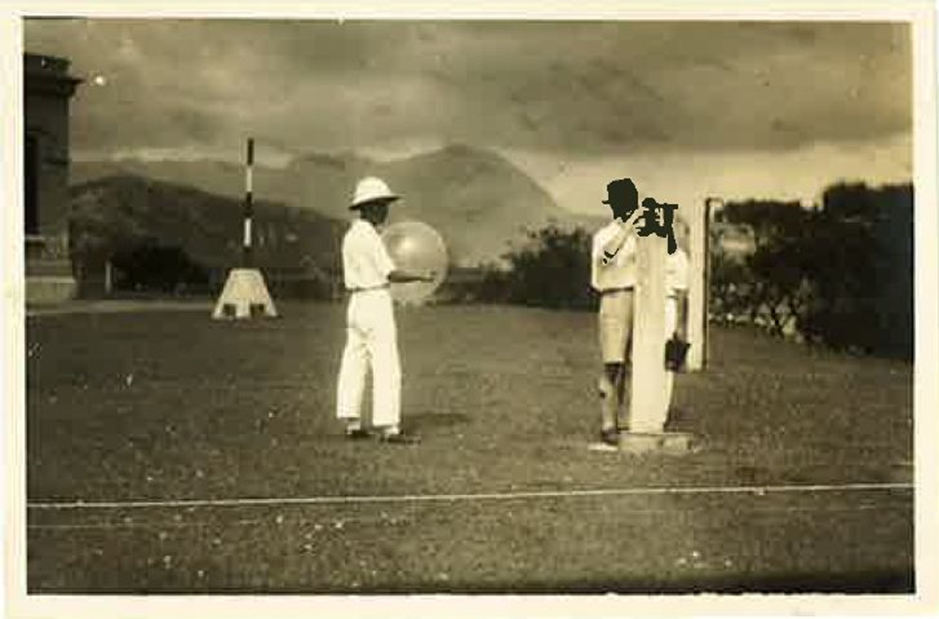
Fig 41: Observatory staff releasing a pilot balloon from the Observatory headquarters in the early 1930s. The person on the left is holding the pilot balloon, and the other member of staff is operating a theodolite, which was used to record the azimuth and elevation angles of the balloon. These measurements could then be used to calculate the speed and direction of upper winds. (Courtesy of family of Mr GSP HEYWOOD)
Summary
The early history of the HKO demonstrates the essential role of science in the development of the Observatory’s services, as well as the organisation’s ability to ascertain and meet the needs of society, develop innovative services and harness new technologies. The Observatory’s work involved an extensive range of scientific fields, including astronomy, meteorology, physics, navigation and communications.
In the early years, its services were clearly targeted at the shipping industry, as well as ensuring maritime and public safety. In order to provide an effective service, communication with the users must be both ways – using the latest communications infrastructure to collect scientific data extensively while at the same time using the same infrastructure to send information to users in a format that was easy to understand. Shipping serving both as a data provider and a client receiving the service has become a model of win-win cooperation that is just as applicable today as it was then, especially in the age of big data.
This chapter of the Observatory’s history covers the period until the start of the Second World War. How did the Observatory re-establish itself following the turmoil of the Second World War? How did it grow to become a world-class meteorological organisation? And how did it continue to improve its aviation weather service and other developing services? Find out the answers to these questions in a later edition of the Hong Kong Laureate Forum Newsletter!
References
- May 2021, Issue number 9.
- The initial British occupation only included Hong Kong Island and the Kowloon Peninsula; the New Territories were not leased until a later date.
- https://collections.rmg.co.uk/collections/objects/100857.html
- https://maps.ngdc.noaa.gov/viewers/historical_declination/
- https://www.ais.gov.hk/HKAIP/aipall.pdf
- https://en.wikipedia.org/wiki/Time_ball
- https://en.wikipedia.org/wiki/Robert_FitzRoy
- Mackeown, Kevin P (2011): "Early China Coast Meteorology: The Role of Hong Kong", Royal Asiatic Society Hong Kong Studies Series, Hong Kong University Press.
- The Surveyor General was subsequently renamed as the Director of Public Works (now Secretary for Development).
- The Harbour Master is now known as the Director of Marine.
- https://www.hko.gov.hk/tc/whatsnew/index.htm?year=2019;Hong Kong Meridian (1): A Mysterious Magic Stone; Hong Kong Meridian (2): Dr Stephen DAVIS and the Mysterious Magic Stone; Hong Kong Meridian (3): In Search of the Lost Magic Stone; Hong Kong Meridian (4): The Last Magic Stone.
- Doberck, William (1883): "Instructions for Making Meteorological Observations Prepared for Use in China", HKO.
- These meteorological stations included Victoria Peak, Cape D'Aguilar, Green Island and Stonecutters Island.
- The Eastern Extension Australasia and China Telegraph Company Limited.
- The Great Northern Telegraph Company Limited.
- Details of how a transit circle is used to determine the local time will be published in the next edition of the Hong Kong Laureate Forum Newsletter.
- http://www.oasi.org.uk/OPO/Telescopes/Tele_transit.jpg
- Except Saturdays (dropping of the time ball at 10 am and 1 pm), Sundays and public holidays (dropping of the time ball at 10 am only).
- Heywood, GSP (2015): "It Won’t Be Long Now: The Diary of a Hong Kong Prisoner of War", Blacksmith Books.
- https://collections.rmg.co.uk/collections/objects/10923.html
- https://www.geomag.nrcan.gc.ca/lab/vm/dover_dip-en.php
- For simplicity, "signal", "code" and "signal code" are all referred to as "signal" in this article.
- https://sunzi.lib.hku.hk/hkgro/view/g1917/51251.pdf
- KY Ma (2020): A History of Telecommunications in Pre-War Hong Kong, Joint Publishing.
- International Commission for the Investigation of the Upper Air.
Author:
Mr SHUN Chi-ming, Former Director of the Hong Kong Observatory
Dr LEE Tsz-cheung, Senior Scientific Officer, Hong Kong Observatory
Dr CHENG Cho-ming, Director of the Hong Kong Observatory
July 2021